You are here: Home > Network List > TA - USArray Transportable Network (new EarthScope stations) Stations List
> Station MSTX Muleshoe, TX, USA > Earthquake Result Viewer
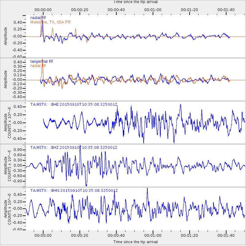
MSTX Muleshoe, TX, USA - Earthquake Result Viewer
*The percent match for this event was below the threshold and hence no stack was calculated.
| Earthquake location: |
Fox Islands, Aleutian Islands |
| Earthquake latitude/longitude: |
52.2/-169.6 |
| Earthquake time(UTC): |
2015/09/10 (253) 10:26:47 GMT |
| Earthquake Depth: |
38 km |
| Earthquake Magnitude: |
5.9 MWP, 5.9 MI |
| Earthquake Catalog/Contributor: |
NEIC PDE/NEIC COMCAT |
|
| Network: |
TA USArray Transportable Network (new EarthScope stations) |
| Station: |
MSTX Muleshoe, TX, USA |
| Lat/Lon: |
33.97 N/102.77 W |
| Elevation: |
1167 m |
|
| Distance: |
50.2 deg |
| Az: |
83.667 deg |
| Baz: |
312.552 deg |
| Ray Param: |
$rayparam |
*The percent match for this event was below the threshold and hence was not used in the summary stack. |
|
| Radial Match: |
67.97393 % |
| Radial Bump: |
400 |
| Transverse Match: |
71.794556 % |
| Transverse Bump: |
400 |
| SOD ConfigId: |
7422571 |
| Insert Time: |
2019-04-20 17:58:25.894 +0000 |
| GWidth: |
2.5 |
| Max Bumps: |
400 |
| Tol: |
0.001 |
|
Signal To Noise
| Channel | StoN | STA | LTA |
| TA:MSTX: :BHZ:20150910T10:35:08.325001Z | 3.070984 | 3.050083E-7 | 9.9319415E-8 |
| TA:MSTX: :BHN:20150910T10:35:08.325001Z | 1.5434035 | 1.4054301E-7 | 9.106044E-8 |
| TA:MSTX: :BHE:20150910T10:35:08.325001Z | 0.5891824 | 5.980563E-8 | 1.01506146E-7 |
| Arrivals |
| Ps | |
| PpPs | |
| PsPs/PpSs | |


