You are here: Home > Network List > TA - USArray Transportable Network (new EarthScope stations) Stations List
> Station SUSD Miller, SD, USA > Earthquake Result Viewer
SUSD Miller, SD, USA - Earthquake Result Viewer
| Earthquake location: |
Fox Islands, Aleutian Islands |
| Earthquake latitude/longitude: |
52.2/-169.6 |
| Earthquake time(UTC): |
2015/09/10 (253) 10:26:47 GMT |
| Earthquake Depth: |
38 km |
| Earthquake Magnitude: |
5.9 MWP, 5.9 MI |
| Earthquake Catalog/Contributor: |
NEIC PDE/NEIC COMCAT |
|
| Network: |
TA USArray Transportable Network (new EarthScope stations) |
| Station: |
SUSD Miller, SD, USA |
| Lat/Lon: |
44.44 N/98.96 W |
| Elevation: |
520 m |
|
| Distance: |
45.9 deg |
| Az: |
70.248 deg |
| Baz: |
305.967 deg |
| Ray Param: |
0.07090522 |
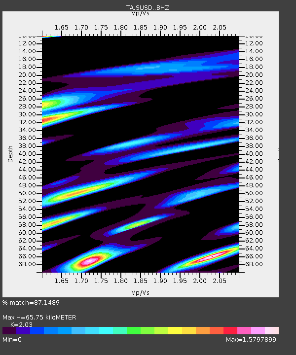
| Estimated Moho Depth: |
65.75 km |
| Estimated Crust Vp/Vs: |
2.03 |
| Assumed Crust Vp: |
6.53 km/s |
| Estimated Crust Vs: |
3.217 km/s |
| Estimated Crust Poisson's Ratio: |
0.34 |
|
| Radial Match: |
87.1489 % |
| Radial Bump: |
400 |
| Transverse Match: |
71.80711 % |
| Transverse Bump: |
400 |
| SOD ConfigId: |
7422571 |
| Insert Time: |
2019-04-20 17:58:33.631 +0000 |
| GWidth: |
2.5 |
| Max Bumps: |
400 |
| Tol: |
0.001 |
|

Signal To Noise
| Channel | StoN | STA | LTA |
| TA:SUSD: :BHZ:20150910T10:34:34.925007Z | 5.357327 | 5.32675E-7 | 9.942925E-8 |
| TA:SUSD: :BHN:20150910T10:34:34.925007Z | 2.3333883 | 2.4487875E-7 | 1.0494556E-7 |
| TA:SUSD: :BHE:20150910T10:34:34.925007Z | 3.4946449 | 3.9794438E-7 | 1.13872616E-7 |
| Arrivals |
| Ps | 11 SECOND |
| PpPs | 29 SECOND |
| PsPs/PpSs | 40 SECOND |


