You are here: Home > Network List > JP - Japan Meteorological Agency Seismic Network Stations List
> Station JWT Kyoto Wachi > Earthquake Result Viewer
JWT Kyoto Wachi - Earthquake Result Viewer
| Earthquake location: |
Northern Sumatra, Indonesia |
| Earthquake latitude/longitude: |
1.5/97.9 |
| Earthquake time(UTC): |
2015/05/08 (128) 03:12:20 GMT |
| Earthquake Depth: |
34 km |
| Earthquake Magnitude: |
5.9 MB |
| Earthquake Catalog/Contributor: |
NEIC PDE/NEIC COMCAT |
|
| Network: |
JP Japan Meteorological Agency Seismic Network |
| Station: |
JWT Kyoto Wachi |
| Lat/Lon: |
35.29 N/135.40 E |
| Elevation: |
172 m |
|
| Distance: |
48.4 deg |
| Az: |
41.797 deg |
| Baz: |
234.527 deg |
| Ray Param: |
0.06931857 |
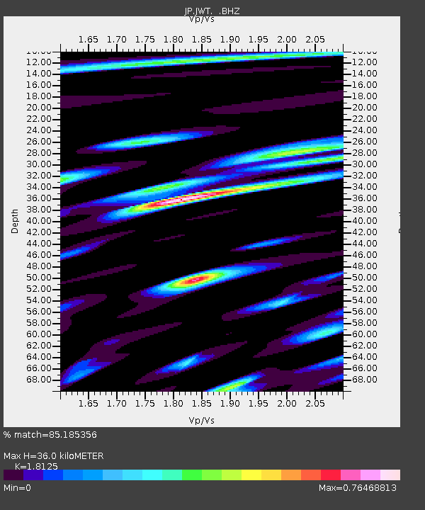
| Estimated Moho Depth: |
36.0 km |
| Estimated Crust Vp/Vs: |
1.81 |
| Assumed Crust Vp: |
6.468 km/s |
| Estimated Crust Vs: |
3.568 km/s |
| Estimated Crust Poisson's Ratio: |
0.28 |
|
| Radial Match: |
85.185356 % |
| Radial Bump: |
400 |
| Transverse Match: |
81.29471 % |
| Transverse Bump: |
400 |
| SOD ConfigId: |
976571 |
| Insert Time: |
2015-05-22 03:43:45.238 +0000 |
| GWidth: |
2.5 |
| Max Bumps: |
400 |
| Tol: |
0.001 |
|

Signal To Noise
| Channel | StoN | STA | LTA |
| JP:JWT: :BHZ:20150508T03:20:28.599985Z | 13.466842 | 8.509626E-7 | 6.318947E-8 |
| JP:JWT: :BHN:20150508T03:20:28.599985Z | 4.60361 | 3.0138736E-7 | 6.546761E-8 |
| JP:JWT: :BHE:20150508T03:20:28.599985Z | 6.910034 | 3.981227E-7 | 5.7615157E-8 |
| Arrivals |
| Ps | 4.8 SECOND |
| PpPs | 15 SECOND |
| PsPs/PpSs | 20 SECOND |


