You are here: Home > Network List > IU - Global Seismograph Network (GSN - IRIS/USGS) Stations List
> Station CHTO Chiang Mai, Thailand > Earthquake Result Viewer
CHTO Chiang Mai, Thailand - Earthquake Result Viewer
| Earthquake location: |
Kuril Islands |
| Earthquake latitude/longitude: |
43.0/146.8 |
| Earthquake time(UTC): |
2000/01/28 (028) 14:21:07 GMT |
| Earthquake Depth: |
61 km |
| Earthquake Magnitude: |
6.7 MB, 6.6 MS, 6.8 MW, 6.8 ME |
| Earthquake Catalog/Contributor: |
WHDF/NEIC |
|
| Network: |
IU Global Seismograph Network (GSN - IRIS/USGS) |
| Station: |
CHTO Chiang Mai, Thailand |
| Lat/Lon: |
18.79 N/98.98 E |
| Elevation: |
316 m |
|
| Distance: |
46.9 deg |
| Az: |
254.289 deg |
| Baz: |
48.152 deg |
| Ray Param: |
0.07018951 |
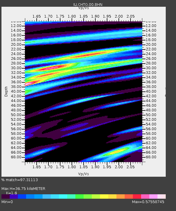
| Estimated Moho Depth: |
36.75 km |
| Estimated Crust Vp/Vs: |
1.60 |
| Assumed Crust Vp: |
6.35 km/s |
| Estimated Crust Vs: |
3.969 km/s |
| Estimated Crust Poisson's Ratio: |
0.18 |
|
| Radial Match: |
97.31113 % |
| Radial Bump: |
277 |
| Transverse Match: |
81.809456 % |
| Transverse Bump: |
400 |
| SOD ConfigId: |
3744 |
| Insert Time: |
2010-03-04 19:23:03.726 +0000 |
| GWidth: |
2.5 |
| Max Bumps: |
400 |
| Tol: |
0.001 |
|
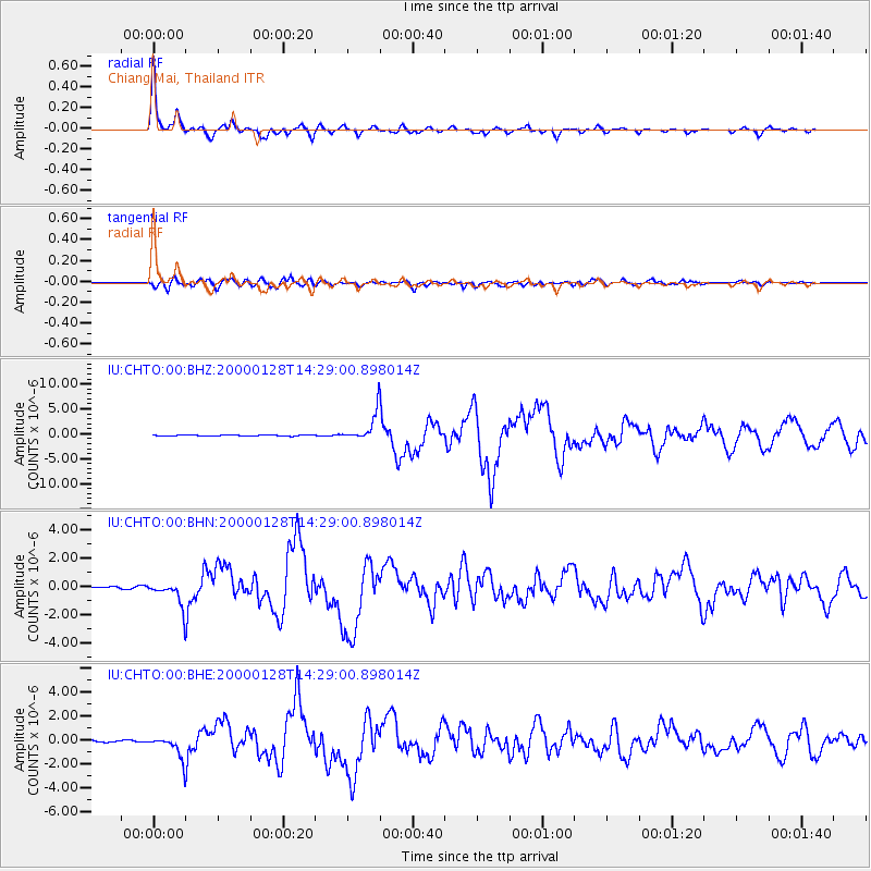
Signal To Noise
| Channel | StoN | STA | LTA |
| IU:CHTO:00:BHN:20000128T14:29:00.898014Z | 13.9431305 | 8.9854586E-7 | 6.4443626E-8 |
| IU:CHTO:00:BHE:20000128T14:29:00.898014Z | 10.290038 | 9.863768E-7 | 9.585745E-8 |
| IU:CHTO:00:BHZ:20000128T14:29:00.898014Z | 25.681076 | 2.8115994E-6 | 1.0948137E-7 |
| Arrivals |
| Ps | 3.7 SECOND |
| PpPs | 14 SECOND |
| PsPs/PpSs | 18 SECOND |


