You are here: Home > Network List > CI - Caltech Regional Seismic Network Stations List
> Station GSC Goldstone, California, USA > Earthquake Result Viewer
GSC Goldstone, California, USA - Earthquake Result Viewer
| Earthquake location: |
Hokkaido, Japan Region |
| Earthquake latitude/longitude: |
43.0/145.1 |
| Earthquake time(UTC): |
2004/11/28 (333) 18:32:14 GMT |
| Earthquake Depth: |
39 km |
| Earthquake Magnitude: |
6.4 MB, 6.7 MS, 7.0 MW, 7.0 MW |
| Earthquake Catalog/Contributor: |
WHDF/NEIC |
|
| Network: |
CI Caltech Regional Seismic Network |
| Station: |
GSC Goldstone, California, USA |
| Lat/Lon: |
35.30 N/116.81 W |
| Elevation: |
954 m |
|
| Distance: |
72.1 deg |
| Az: |
58.303 deg |
| Baz: |
310.265 deg |
| Ray Param: |
0.053793818 |
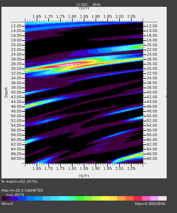
| Estimated Moho Depth: |
28.0 km |
| Estimated Crust Vp/Vs: |
1.81 |
| Assumed Crust Vp: |
6.276 km/s |
| Estimated Crust Vs: |
3.472 km/s |
| Estimated Crust Poisson's Ratio: |
0.28 |
|
| Radial Match: |
92.34751 % |
| Radial Bump: |
400 |
| Transverse Match: |
89.29235 % |
| Transverse Bump: |
400 |
| SOD ConfigId: |
2459 |
| Insert Time: |
2010-02-25 23:42:45.545 +0000 |
| GWidth: |
2.5 |
| Max Bumps: |
400 |
| Tol: |
0.001 |
|
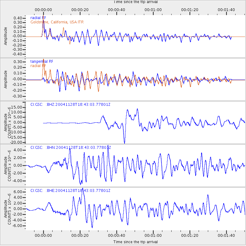
Signal To Noise
| Channel | StoN | STA | LTA |
| CI:GSC: :BHN:20041128T18:43:03.77801Z | 4.135227 | 8.902787E-7 | 2.1529138E-7 |
| CI:GSC: :BHE:20041128T18:43:03.77801Z | 5.946212 | 1.3016664E-6 | 2.1890683E-7 |
| CI:GSC: :BHZ:20041128T18:43:03.77801Z | 19.603533 | 3.435124E-6 | 1.7522984E-7 |
| Arrivals |
| Ps | 3.7 SECOND |
| PpPs | 12 SECOND |
| PsPs/PpSs | 16 SECOND |


