You are here: Home > Network List > TA - USArray Transportable Network (new EarthScope stations) Stations List
> Station O03E Paynes Creek, CA, USA > Earthquake Result Viewer
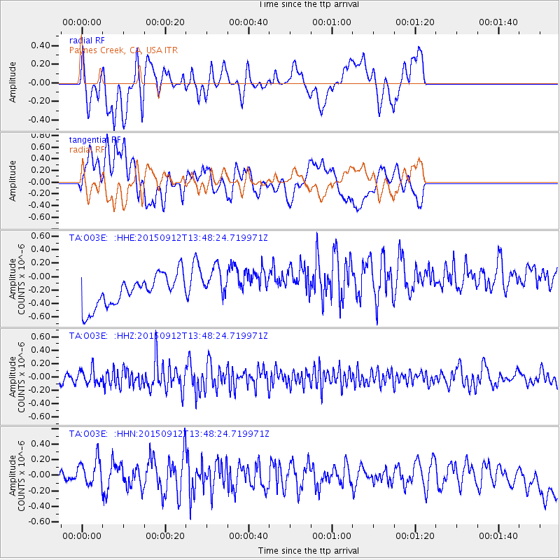
O03E Paynes Creek, CA, USA - Earthquake Result Viewer
*The percent match for this event was below the threshold and hence no stack was calculated.
| Earthquake location: |
Hokkaido, Japan Region |
| Earthquake latitude/longitude: |
41.9/142.6 |
| Earthquake time(UTC): |
2015/09/12 (255) 13:38:01 GMT |
| Earthquake Depth: |
49 km |
| Earthquake Magnitude: |
5.5 mwc |
| Earthquake Catalog/Contributor: |
NEIC PDE/ |
|
| Network: |
TA USArray Transportable Network (new EarthScope stations) |
| Station: |
O03E Paynes Creek, CA, USA |
| Lat/Lon: |
40.29 N/121.80 W |
| Elevation: |
967 m |
|
| Distance: |
68.1 deg |
| Az: |
55.149 deg |
| Baz: |
306.777 deg |
| Ray Param: |
$rayparam |
*The percent match for this event was below the threshold and hence was not used in the summary stack. |
|
| Radial Match: |
45.73599 % |
| Radial Bump: |
400 |
| Transverse Match: |
23.830856 % |
| Transverse Bump: |
400 |
| SOD ConfigId: |
7422571 |
| Insert Time: |
2019-04-20 18:14:41.730 +0000 |
| GWidth: |
2.5 |
| Max Bumps: |
400 |
| Tol: |
0.001 |
|
Signal To Noise
| Channel | StoN | STA | LTA |
| TA:O03E: :HHZ:20150912T13:48:24.719971Z | 0.9902699 | 1.121084E-7 | 1.1320995E-7 |
| TA:O03E: :HHN:20150912T13:48:24.719971Z | 1.6681384 | 2.4341642E-7 | 1.45921E-7 |
| TA:O03E: :HHE:20150912T13:48:24.719971Z | 1.1126 | 2.555693E-7 | 2.2970455E-7 |
| Arrivals |
| Ps | |
| PpPs | |
| PsPs/PpSs | |


