You are here: Home > Network List > US - United States National Seismic Network Stations List
> Station EGMT Eagleton, Montana, USA > Earthquake Result Viewer
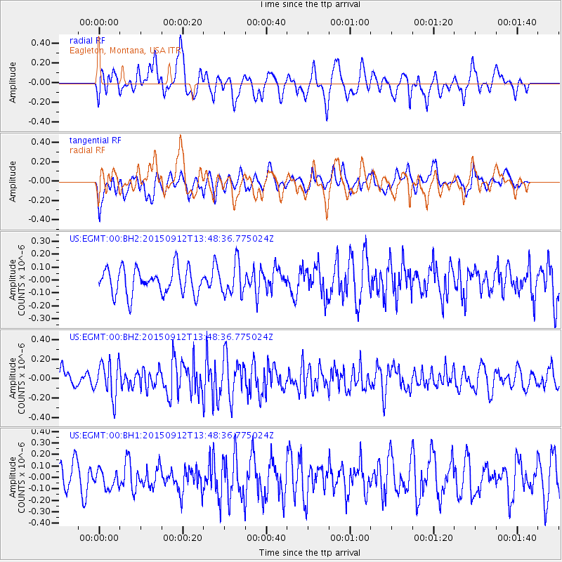
EGMT Eagleton, Montana, USA - Earthquake Result Viewer
*The percent match for this event was below the threshold and hence no stack was calculated.
| Earthquake location: |
Hokkaido, Japan Region |
| Earthquake latitude/longitude: |
41.9/142.6 |
| Earthquake time(UTC): |
2015/09/12 (255) 13:38:01 GMT |
| Earthquake Depth: |
49 km |
| Earthquake Magnitude: |
5.5 mwc |
| Earthquake Catalog/Contributor: |
NEIC PDE/ |
|
| Network: |
US United States National Seismic Network |
| Station: |
EGMT Eagleton, Montana, USA |
| Lat/Lon: |
48.02 N/109.75 W |
| Elevation: |
1055 m |
|
| Distance: |
70.0 deg |
| Az: |
42.911 deg |
| Baz: |
310.785 deg |
| Ray Param: |
$rayparam |
*The percent match for this event was below the threshold and hence was not used in the summary stack. |
|
| Radial Match: |
59.928074 % |
| Radial Bump: |
400 |
| Transverse Match: |
55.00922 % |
| Transverse Bump: |
400 |
| SOD ConfigId: |
7422571 |
| Insert Time: |
2019-04-20 18:15:19.508 +0000 |
| GWidth: |
2.5 |
| Max Bumps: |
400 |
| Tol: |
0.001 |
|
Signal To Noise
| Channel | StoN | STA | LTA |
| US:EGMT:00:BHZ:20150912T13:48:36.775024Z | 1.7043204 | 1.8381644E-7 | 1.0785322E-7 |
| US:EGMT:00:BH1:20150912T13:48:36.775024Z | 0.7891852 | 8.84295E-8 | 1.12051644E-7 |
| US:EGMT:00:BH2:20150912T13:48:36.775024Z | 1.2191116 | 1.2464793E-7 | 1.0224489E-7 |
| Arrivals |
| Ps | |
| PpPs | |
| PsPs/PpSs | |


