You are here: Home > Network List > UW - Pacific Northwest Regional Seismic Network Stations List
> Station UMAT Pilot Rock, OR, USA > Earthquake Result Viewer
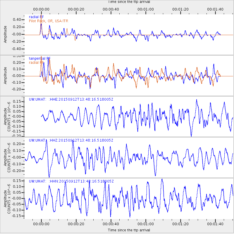
UMAT Pilot Rock, OR, USA - Earthquake Result Viewer
*The percent match for this event was below the threshold and hence no stack was calculated.
| Earthquake location: |
Hokkaido, Japan Region |
| Earthquake latitude/longitude: |
41.9/142.6 |
| Earthquake time(UTC): |
2015/09/12 (255) 13:38:01 GMT |
| Earthquake Depth: |
49 km |
| Earthquake Magnitude: |
5.5 mwc |
| Earthquake Catalog/Contributor: |
NEIC PDE/ |
|
| Network: |
UW Pacific Northwest Regional Seismic Network |
| Station: |
UMAT Pilot Rock, OR, USA |
| Lat/Lon: |
45.29 N/118.96 W |
| Elevation: |
1318 m |
|
| Distance: |
66.8 deg |
| Az: |
49.458 deg |
| Baz: |
306.516 deg |
| Ray Param: |
$rayparam |
*The percent match for this event was below the threshold and hence was not used in the summary stack. |
|
| Radial Match: |
62.734657 % |
| Radial Bump: |
400 |
| Transverse Match: |
63.87299 % |
| Transverse Bump: |
348 |
| SOD ConfigId: |
7422571 |
| Insert Time: |
2019-04-20 18:15:52.106 +0000 |
| GWidth: |
2.5 |
| Max Bumps: |
400 |
| Tol: |
0.001 |
|
Signal To Noise
| Channel | StoN | STA | LTA |
| UW:UMAT: :HHZ:20150912T13:48:16.518005Z | 2.8942158 | 1.42541E-7 | 4.92503E-8 |
| UW:UMAT: :HHN:20150912T13:48:16.518005Z | 1.0243629 | 5.7919856E-8 | 5.654232E-8 |
| UW:UMAT: :HHE:20150912T13:48:16.518005Z | 1.8756034 | 7.8786684E-8 | 4.2006047E-8 |
| Arrivals |
| Ps | |
| PpPs | |
| PsPs/PpSs | |


