You are here: Home > Network List > AV - Alaska Volcano Observatory Stations List
> Station AMKA Regional Station, Amchitka Island, Alaska > Earthquake Result Viewer
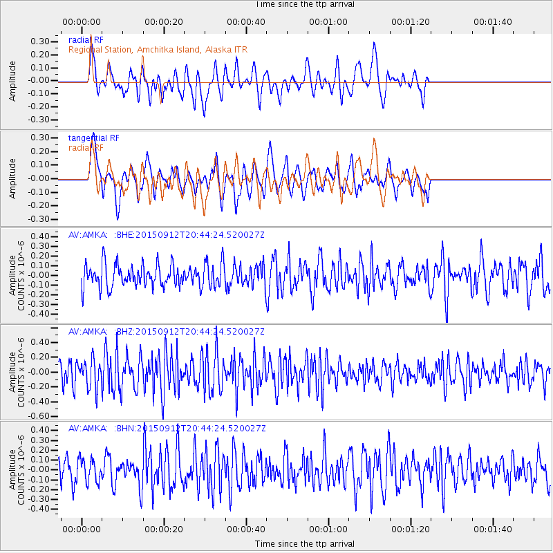
AMKA Regional Station, Amchitka Island, Alaska - Earthquake Result Viewer
*The percent match for this event was below the threshold and hence no stack was calculated.
| Earthquake location: |
South Of Kermadec Islands |
| Earthquake latitude/longitude: |
-32.5/-177.9 |
| Earthquake time(UTC): |
2015/09/12 (255) 20:32:25 GMT |
| Earthquake Depth: |
10 km |
| Earthquake Magnitude: |
5.7 MB |
| Earthquake Catalog/Contributor: |
NEIC PDE/NEIC COMCAT |
|
| Network: |
AV Alaska Volcano Observatory |
| Station: |
AMKA Regional Station, Amchitka Island, Alaska |
| Lat/Lon: |
51.38 N/179.30 E |
| Elevation: |
116 m |
|
| Distance: |
83.6 deg |
| Az: |
358.25 deg |
| Baz: |
177.64 deg |
| Ray Param: |
$rayparam |
*The percent match for this event was below the threshold and hence was not used in the summary stack. |
|
| Radial Match: |
51.736805 % |
| Radial Bump: |
356 |
| Transverse Match: |
56.53985 % |
| Transverse Bump: |
400 |
| SOD ConfigId: |
7422571 |
| Insert Time: |
2019-04-20 18:18:43.142 +0000 |
| GWidth: |
2.5 |
| Max Bumps: |
400 |
| Tol: |
0.001 |
|
Signal To Noise
| Channel | StoN | STA | LTA |
| AV:AMKA: :BHZ:20150912T20:44:24.520027Z | 1.4763011 | 1.9028671E-7 | 1.2889424E-7 |
| AV:AMKA: :BHN:20150912T20:44:24.520027Z | 1.2775823 | 1.1522881E-7 | 9.019286E-8 |
| AV:AMKA: :BHE:20150912T20:44:24.520027Z | 0.9548837 | 1.12022725E-7 | 1.1731557E-7 |
| Arrivals |
| Ps | |
| PpPs | |
| PsPs/PpSs | |


