You are here: Home > Network List > IU - Global Seismograph Network (GSN - IRIS/USGS) Stations List
> Station CHTO Chiang Mai, Thailand > Earthquake Result Viewer
CHTO Chiang Mai, Thailand - Earthquake Result Viewer

| Earthquake location: |
Kuril Islands |
| Earthquake latitude/longitude: |
44.3/148.4 |
| Earthquake time(UTC): |
2001/05/25 (145) 00:40:50 GMT |
| Earthquake Depth: |
33 km |
| Earthquake Magnitude: |
6.1 MB, 6.7 MS, 6.7 MW, 6.6 MW |
| Earthquake Catalog/Contributor: |
WHDF/NEIC |
|
| Network: |
IU Global Seismograph Network (GSN - IRIS/USGS) |
| Station: |
CHTO Chiang Mai, Thailand |
| Lat/Lon: |
18.79 N/98.98 E |
| Elevation: |
316 m |
|
| Distance: |
48.3 deg |
| Az: |
254.561 deg |
| Baz: |
46.968 deg |
| Ray Param: |
0.069399826 |
| Estimated Moho Depth: |
25.75 km |
| Estimated Crust Vp/Vs: |
1.79 |
| Assumed Crust Vp: |
6.35 km/s |
| Estimated Crust Vs: |
3.552 km/s |
| Estimated Crust Poisson's Ratio: |
0.27 |
|
| Radial Match: |
97.31961 % |
| Radial Bump: |
389 |
| Transverse Match: |
90.596985 % |
| Transverse Bump: |
400 |
| SOD ConfigId: |
4714 |
| Insert Time: |
2010-03-04 19:26:04.052 +0000 |
| GWidth: |
2.5 |
| Max Bumps: |
400 |
| Tol: |
0.001 |
|
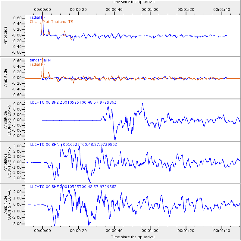
Signal To Noise
| Channel | StoN | STA | LTA |
| IU:CHTO:00:BHN:20010525T00:48:57.972986Z | 9.233972 | 4.240944E-7 | 4.5927624E-8 |
| IU:CHTO:00:BHE:20010525T00:48:57.972986Z | 9.773781 | 3.816315E-7 | 3.904646E-8 |
| IU:CHTO:00:BHZ:20010525T00:48:57.972986Z | 18.083456 | 1.0492932E-6 | 5.802504E-8 |
| Arrivals |
| Ps | 3.4 SECOND |
| PpPs | 11 SECOND |
| PsPs/PpSs | 14 SECOND |


