You are here: Home > Network List > CI - Caltech Regional Seismic Network Stations List
> Station GSC Goldstone, California, USA > Earthquake Result Viewer
GSC Goldstone, California, USA - Earthquake Result Viewer
| Earthquake location: |
Tonga Islands |
| Earthquake latitude/longitude: |
-16.8/-174.2 |
| Earthquake time(UTC): |
2004/01/25 (025) 11:43:11 GMT |
| Earthquake Depth: |
130 km |
| Earthquake Magnitude: |
6.4 MB, 6.7 MW, 6.7 MW |
| Earthquake Catalog/Contributor: |
WHDF/NEIC |
|
| Network: |
CI Caltech Regional Seismic Network |
| Station: |
GSC Goldstone, California, USA |
| Lat/Lon: |
35.30 N/116.81 W |
| Elevation: |
954 m |
|
| Distance: |
75.1 deg |
| Az: |
45.469 deg |
| Baz: |
236.583 deg |
| Ray Param: |
0.05155442 |
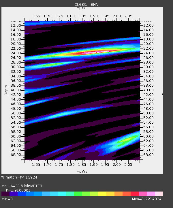
| Estimated Moho Depth: |
23.5 km |
| Estimated Crust Vp/Vs: |
1.91 |
| Assumed Crust Vp: |
6.276 km/s |
| Estimated Crust Vs: |
3.286 km/s |
| Estimated Crust Poisson's Ratio: |
0.31 |
|
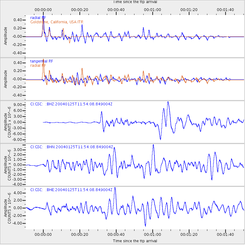
| Radial Match: |
94.13924 % |
| Radial Bump: |
381 |
| Transverse Match: |
90.66137 % |
| Transverse Bump: |
400 |
| SOD ConfigId: |
2459 |
| Insert Time: |
2010-02-25 23:42:56.641 +0000 |
| GWidth: |
2.5 |
| Max Bumps: |
400 |
| Tol: |
0.001 |
|
Signal To Noise
| Channel | StoN | STA | LTA |
| CI:GSC: :BHN:20040125T11:54:08.849004Z | 3.2043347 | 6.268592E-7 | 1.956285E-7 |
| CI:GSC: :BHE:20040125T11:54:08.849004Z | 3.147716 | 7.5917114E-7 | 2.4118157E-7 |
| CI:GSC: :BHZ:20040125T11:54:08.849004Z | 18.369322 | 2.4437795E-6 | 1.3303591E-7 |
| Arrivals |
| Ps | 3.5 SECOND |
| PpPs | 11 SECOND |
| PsPs/PpSs | 14 SECOND |


