You are here: Home > Network List > PF - Volcanologic Network of Piton de Fournaise-OVPF Stations List
> Station CIL Cilaos (Pompiers) > Earthquake Result Viewer
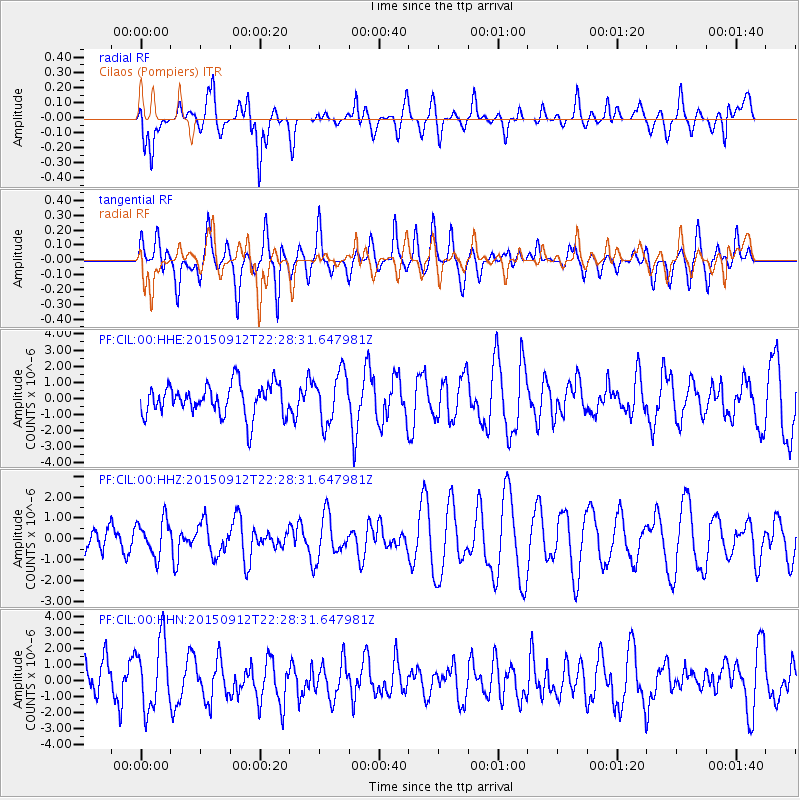
CIL Cilaos (Pompiers) - Earthquake Result Viewer
*The percent match for this event was below the threshold and hence no stack was calculated.
| Earthquake location: |
Eastern New Guinea Reg., P.N.G. |
| Earthquake latitude/longitude: |
-6.1/147.3 |
| Earthquake time(UTC): |
2015/09/12 (255) 22:16:10 GMT |
| Earthquake Depth: |
46 km |
| Earthquake Magnitude: |
5.5 MB |
| Earthquake Catalog/Contributor: |
NEIC PDE/NEIC COMCAT |
|
| Network: |
PF Volcanologic Network of Piton de Fournaise-OVPF |
| Station: |
CIL Cilaos (Pompiers) |
| Lat/Lon: |
21.13 S/55.47 E |
| Elevation: |
1223 m |
|
| Distance: |
89.6 deg |
| Az: |
248.921 deg |
| Baz: |
96.349 deg |
| Ray Param: |
$rayparam |
*The percent match for this event was below the threshold and hence was not used in the summary stack. |
|
| Radial Match: |
50.473316 % |
| Radial Bump: |
400 |
| Transverse Match: |
48.525772 % |
| Transverse Bump: |
400 |
| SOD ConfigId: |
7422571 |
| Insert Time: |
2019-04-20 18:25:49.630 +0000 |
| GWidth: |
2.5 |
| Max Bumps: |
400 |
| Tol: |
0.001 |
|
Signal To Noise
| Channel | StoN | STA | LTA |
| PF:CIL:00:HHZ:20150912T22:28:31.647981Z | 0.87838733 | 8.5082854E-7 | 9.686257E-7 |
| PF:CIL:00:HHN:20150912T22:28:31.647981Z | 2.2165012 | 2.1237531E-6 | 9.581557E-7 |
| PF:CIL:00:HHE:20150912T22:28:31.647981Z | 1.591802 | 1.5547262E-6 | 9.767083E-7 |
| Arrivals |
| Ps | |
| PpPs | |
| PsPs/PpSs | |


