You are here: Home > Network List > TA - USArray Transportable Network (new EarthScope stations) Stations List
> Station L20K Farewell, AK, USA > Earthquake Result Viewer
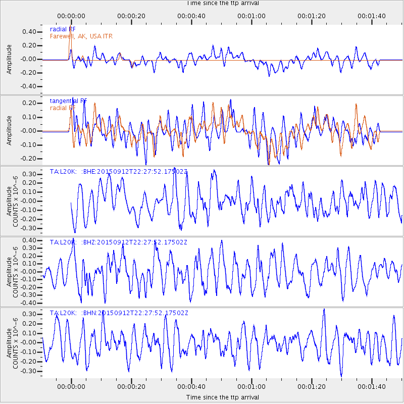
L20K Farewell, AK, USA - Earthquake Result Viewer
*The percent match for this event was below the threshold and hence no stack was calculated.
| Earthquake location: |
Eastern New Guinea Reg., P.N.G. |
| Earthquake latitude/longitude: |
-6.1/147.3 |
| Earthquake time(UTC): |
2015/09/12 (255) 22:16:10 GMT |
| Earthquake Depth: |
46 km |
| Earthquake Magnitude: |
5.5 MB |
| Earthquake Catalog/Contributor: |
NEIC PDE/NEIC COMCAT |
|
| Network: |
TA USArray Transportable Network (new EarthScope stations) |
| Station: |
L20K Farewell, AK, USA |
| Lat/Lon: |
62.48 N/153.88 W |
| Elevation: |
673 m |
|
| Distance: |
81.6 deg |
| Az: |
23.674 deg |
| Baz: |
239.265 deg |
| Ray Param: |
$rayparam |
*The percent match for this event was below the threshold and hence was not used in the summary stack. |
|
| Radial Match: |
40.860912 % |
| Radial Bump: |
400 |
| Transverse Match: |
57.68066 % |
| Transverse Bump: |
400 |
| SOD ConfigId: |
7422571 |
| Insert Time: |
2019-04-20 18:26:13.342 +0000 |
| GWidth: |
2.5 |
| Max Bumps: |
400 |
| Tol: |
0.001 |
|
Signal To Noise
| Channel | StoN | STA | LTA |
| TA:L20K: :BHZ:20150912T22:27:52.17502Z | 2.1038423 | 2.3573138E-7 | 1.1204803E-7 |
| TA:L20K: :BHN:20150912T22:27:52.17502Z | 0.7750941 | 1.4420908E-7 | 1.8605364E-7 |
| TA:L20K: :BHE:20150912T22:27:52.17502Z | 0.94827646 | 1.6075572E-7 | 1.695241E-7 |
| Arrivals |
| Ps | |
| PpPs | |
| PsPs/PpSs | |


