You are here: Home > Network List > ZQ15 - Taku Glacier Stations List
> Station GAGA Taku Glacier, Alaska, USA > Earthquake Result Viewer
GAGA Taku Glacier, Alaska, USA - Earthquake Result Viewer
| Earthquake location: |
Eastern New Guinea Reg., P.N.G. |
| Earthquake latitude/longitude: |
-6.1/147.3 |
| Earthquake time(UTC): |
2015/09/12 (255) 22:16:10 GMT |
| Earthquake Depth: |
46 km |
| Earthquake Magnitude: |
5.5 MB |
| Earthquake Catalog/Contributor: |
NEIC PDE/NEIC COMCAT |
|
| Network: |
ZQ Taku Glacier |
| Station: |
GAGA Taku Glacier, Alaska, USA |
| Lat/Lon: |
58.44 N/134.05 W |
| Elevation: |
258 m |
|
| Distance: |
89.3 deg |
| Az: |
31.04 deg |
| Baz: |
257.131 deg |
| Ray Param: |
0.04191597 |
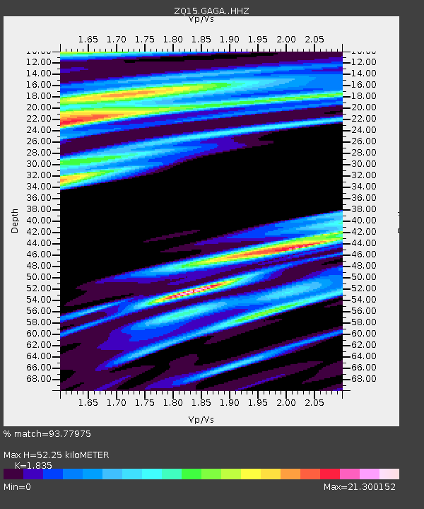
| Estimated Moho Depth: |
52.25 km |
| Estimated Crust Vp/Vs: |
1.84 |
| Assumed Crust Vp: |
6.566 km/s |
| Estimated Crust Vs: |
3.578 km/s |
| Estimated Crust Poisson's Ratio: |
0.29 |
|
| Radial Match: |
93.77975 % |
| Radial Bump: |
355 |
| Transverse Match: |
80.88496 % |
| Transverse Bump: |
256 |
| SOD ConfigId: |
7422571 |
| Insert Time: |
2019-04-20 18:27:52.475 +0000 |
| GWidth: |
2.5 |
| Max Bumps: |
400 |
| Tol: |
0.001 |
|

Signal To Noise
| Channel | StoN | STA | LTA |
| ZQ:GAGA: :HHZ:20150912T22:28:29.980012Z | 0.929913 | 9.512176E-8 | 1.0229104E-7 |
| ZQ:GAGA: :HH1:20150912T22:28:29.980012Z | 0.4726491 | 1.724879E-6 | 3.649386E-6 |
| ZQ:GAGA: :HH2:20150912T22:28:29.980012Z | 2.2506495 | 1.003135E-5 | 4.457091E-6 |
| Arrivals |
| Ps | 6.8 SECOND |
| PpPs | 22 SECOND |
| PsPs/PpSs | 29 SECOND |


