You are here: Home > Network List > AK - Alaska Regional Network Stations List
> Station MDM Murphy Dome > Earthquake Result Viewer
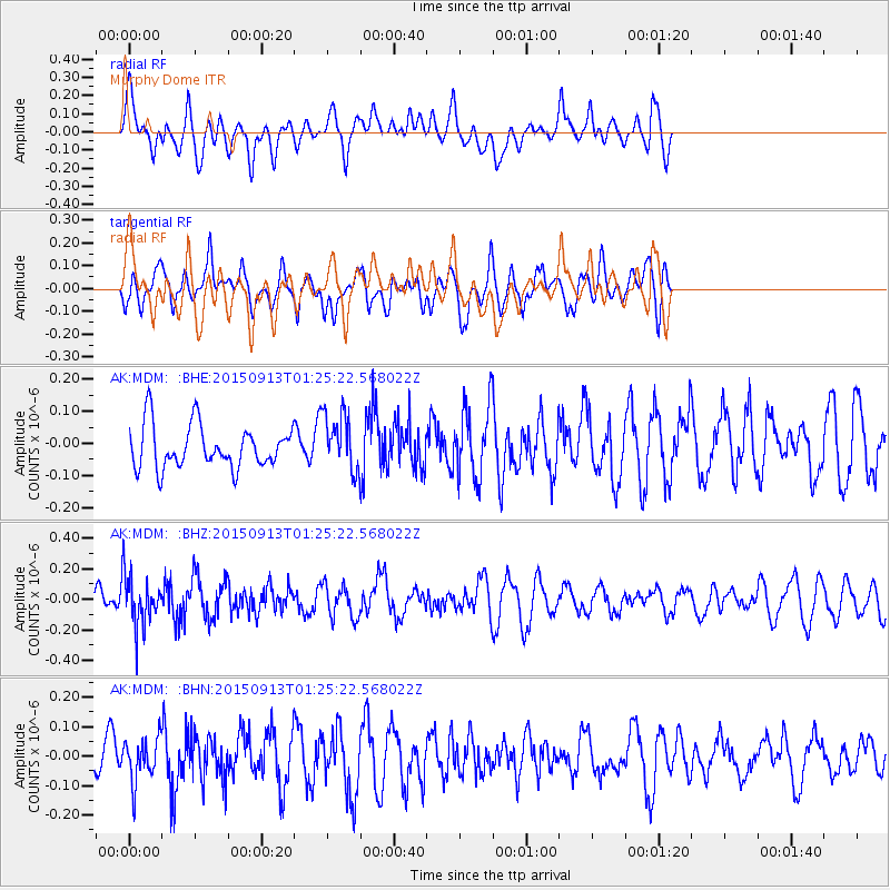
MDM Murphy Dome - Earthquake Result Viewer
*The percent match for this event was below the threshold and hence no stack was calculated.
| Earthquake location: |
Minahassa Peninsula, Sulawesi |
| Earthquake latitude/longitude: |
0.1/123.4 |
| Earthquake time(UTC): |
2015/09/13 (256) 01:13:12 GMT |
| Earthquake Depth: |
123 km |
| Earthquake Magnitude: |
5.8 MB |
| Earthquake Catalog/Contributor: |
NEIC PDE/NEIC COMCAT |
|
| Network: |
AK Alaska Regional Network |
| Station: |
MDM Murphy Dome |
| Lat/Lon: |
64.96 N/148.23 W |
| Elevation: |
634 m |
|
| Distance: |
89.2 deg |
| Az: |
25.181 deg |
| Baz: |
268.574 deg |
| Ray Param: |
$rayparam |
*The percent match for this event was below the threshold and hence was not used in the summary stack. |
|
| Radial Match: |
62.42195 % |
| Radial Bump: |
400 |
| Transverse Match: |
57.57912 % |
| Transverse Bump: |
400 |
| SOD ConfigId: |
7422571 |
| Insert Time: |
2019-04-20 18:28:45.844 +0000 |
| GWidth: |
2.5 |
| Max Bumps: |
400 |
| Tol: |
0.001 |
|
Signal To Noise
| Channel | StoN | STA | LTA |
| AK:MDM: :BHZ:20150913T01:25:22.568022Z | 2.8092265 | 1.6287797E-7 | 5.797965E-8 |
| AK:MDM: :BHN:20150913T01:25:22.568022Z | 1.0687263 | 7.300385E-8 | 6.830921E-8 |
| AK:MDM: :BHE:20150913T01:25:22.568022Z | 1.3558778 | 9.138206E-8 | 6.739698E-8 |
| Arrivals |
| Ps | |
| PpPs | |
| PsPs/PpSs | |


