You are here: Home > Network List > CN - Canadian National Seismograph Network Stations List
> Station INK INUVIK, NT > Earthquake Result Viewer
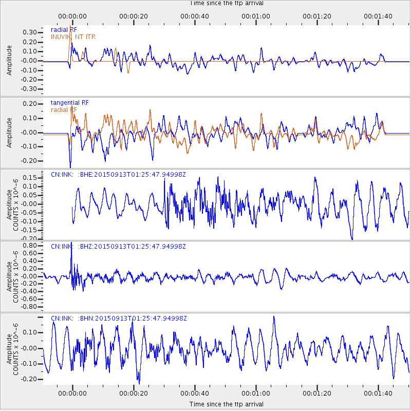
INK INUVIK, NT - Earthquake Result Viewer
*The percent match for this event was below the threshold and hence no stack was calculated.
| Earthquake location: |
Minahassa Peninsula, Sulawesi |
| Earthquake latitude/longitude: |
0.1/123.4 |
| Earthquake time(UTC): |
2015/09/13 (256) 01:13:12 GMT |
| Earthquake Depth: |
123 km |
| Earthquake Magnitude: |
5.8 MB |
| Earthquake Catalog/Contributor: |
NEIC PDE/NEIC COMCAT |
|
| Network: |
CN Canadian National Seismograph Network |
| Station: |
INK INUVIK, NT |
| Lat/Lon: |
68.31 N/133.53 W |
| Elevation: |
44 m |
|
| Distance: |
94.7 deg |
| Az: |
21.308 deg |
| Baz: |
282.206 deg |
| Ray Param: |
$rayparam |
*The percent match for this event was below the threshold and hence was not used in the summary stack. |
|
| Radial Match: |
41.941265 % |
| Radial Bump: |
400 |
| Transverse Match: |
31.977049 % |
| Transverse Bump: |
400 |
| SOD ConfigId: |
7422571 |
| Insert Time: |
2019-04-20 18:29:38.857 +0000 |
| GWidth: |
2.5 |
| Max Bumps: |
400 |
| Tol: |
0.001 |
|
Signal To Noise
| Channel | StoN | STA | LTA |
| CN:INK: :BHZ:20150913T01:25:47.94998Z | 2.6399424 | 2.3423226E-7 | 8.872628E-8 |
| CN:INK: :BHN:20150913T01:25:47.94998Z | 0.9238645 | 6.6590395E-8 | 7.20781E-8 |
| CN:INK: :BHE:20150913T01:25:47.94998Z | 1.4926606 | 6.910386E-8 | 4.629576E-8 |
| Arrivals |
| Ps | |
| PpPs | |
| PsPs/PpSs | |


