You are here: Home > Network List > TA - USArray Transportable Network (new EarthScope stations) Stations List
> Station J25K Salcha River, AK, USA > Earthquake Result Viewer
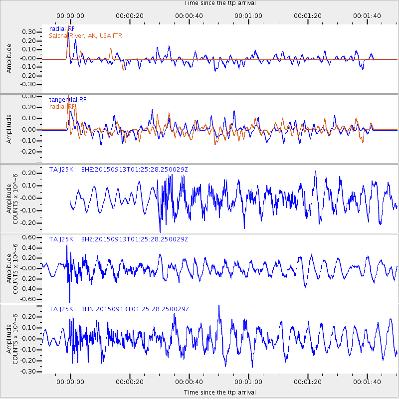
J25K Salcha River, AK, USA - Earthquake Result Viewer
*The percent match for this event was below the threshold and hence no stack was calculated.
| Earthquake location: |
Minahassa Peninsula, Sulawesi |
| Earthquake latitude/longitude: |
0.1/123.4 |
| Earthquake time(UTC): |
2015/09/13 (256) 01:13:12 GMT |
| Earthquake Depth: |
123 km |
| Earthquake Magnitude: |
5.8 MB |
| Earthquake Catalog/Contributor: |
NEIC PDE/NEIC COMCAT |
|
| Network: |
TA USArray Transportable Network (new EarthScope stations) |
| Station: |
J25K Salcha River, AK, USA |
| Lat/Lon: |
64.61 N/145.37 W |
| Elevation: |
949 m |
|
| Distance: |
90.4 deg |
| Az: |
25.531 deg |
| Baz: |
271.159 deg |
| Ray Param: |
$rayparam |
*The percent match for this event was below the threshold and hence was not used in the summary stack. |
|
| Radial Match: |
44.365612 % |
| Radial Bump: |
400 |
| Transverse Match: |
40.605297 % |
| Transverse Bump: |
395 |
| SOD ConfigId: |
7422571 |
| Insert Time: |
2019-04-20 18:31:10.363 +0000 |
| GWidth: |
2.5 |
| Max Bumps: |
400 |
| Tol: |
0.001 |
|
Signal To Noise
| Channel | StoN | STA | LTA |
| TA:J25K: :BHZ:20150913T01:25:28.250029Z | 2.186976 | 1.7793705E-7 | 8.1362145E-8 |
| TA:J25K: :BHN:20150913T01:25:28.250029Z | 0.9901304 | 9.324962E-8 | 9.417913E-8 |
| TA:J25K: :BHE:20150913T01:25:28.250029Z | 1.9384692 | 1.2000031E-7 | 6.190468E-8 |
| Arrivals |
| Ps | |
| PpPs | |
| PsPs/PpSs | |


