You are here: Home > Network List > TA - USArray Transportable Network (new EarthScope stations) Stations List
> Station L20K Farewell, AK, USA > Earthquake Result Viewer
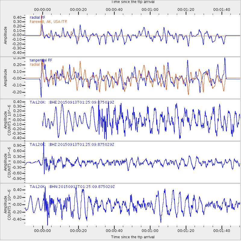
L20K Farewell, AK, USA - Earthquake Result Viewer
*The percent match for this event was below the threshold and hence no stack was calculated.
| Earthquake location: |
Minahassa Peninsula, Sulawesi |
| Earthquake latitude/longitude: |
0.1/123.4 |
| Earthquake time(UTC): |
2015/09/13 (256) 01:13:12 GMT |
| Earthquake Depth: |
123 km |
| Earthquake Magnitude: |
5.8 MB |
| Earthquake Catalog/Contributor: |
NEIC PDE/NEIC COMCAT |
|
| Network: |
TA USArray Transportable Network (new EarthScope stations) |
| Station: |
L20K Farewell, AK, USA |
| Lat/Lon: |
62.48 N/153.88 W |
| Elevation: |
673 m |
|
| Distance: |
86.5 deg |
| Az: |
27.492 deg |
| Baz: |
263.599 deg |
| Ray Param: |
$rayparam |
*The percent match for this event was below the threshold and hence was not used in the summary stack. |
|
| Radial Match: |
43.57297 % |
| Radial Bump: |
400 |
| Transverse Match: |
42.82328 % |
| Transverse Bump: |
400 |
| SOD ConfigId: |
7422571 |
| Insert Time: |
2019-04-20 18:31:12.880 +0000 |
| GWidth: |
2.5 |
| Max Bumps: |
400 |
| Tol: |
0.001 |
|
Signal To Noise
| Channel | StoN | STA | LTA |
| TA:L20K: :BHZ:20150913T01:25:09.875029Z | 2.328121 | 3.127954E-7 | 1.3435532E-7 |
| TA:L20K: :BHN:20150913T01:25:09.875029Z | 1.3429163 | 1.9930026E-7 | 1.4840856E-7 |
| TA:L20K: :BHE:20150913T01:25:09.875029Z | 1.1332617 | 1.7963546E-7 | 1.585119E-7 |
| Arrivals |
| Ps | |
| PpPs | |
| PsPs/PpSs | |


