You are here: Home > Network List > TJ - Tajikistan National Seismic Network Stations List
> Station GARM Garm, Tajikistan > Earthquake Result Viewer
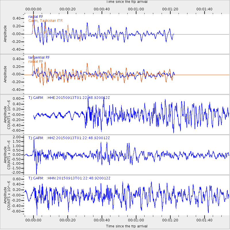
GARM Garm, Tajikistan - Earthquake Result Viewer
*The percent match for this event was below the threshold and hence no stack was calculated.
| Earthquake location: |
Minahassa Peninsula, Sulawesi |
| Earthquake latitude/longitude: |
0.1/123.4 |
| Earthquake time(UTC): |
2015/09/13 (256) 01:13:12 GMT |
| Earthquake Depth: |
123 km |
| Earthquake Magnitude: |
5.8 MB |
| Earthquake Catalog/Contributor: |
NEIC PDE/NEIC COMCAT |
|
| Network: |
TJ Tajikistan National Seismic Network |
| Station: |
GARM Garm, Tajikistan |
| Lat/Lon: |
39.00 N/70.32 E |
| Elevation: |
1305 m |
|
| Distance: |
62.0 deg |
| Az: |
315.12 deg |
| Baz: |
115.101 deg |
| Ray Param: |
$rayparam |
*The percent match for this event was below the threshold and hence was not used in the summary stack. |
|
| Radial Match: |
71.779564 % |
| Radial Bump: |
400 |
| Transverse Match: |
53.160942 % |
| Transverse Bump: |
400 |
| SOD ConfigId: |
7422571 |
| Insert Time: |
2019-04-20 18:31:23.572 +0000 |
| GWidth: |
2.5 |
| Max Bumps: |
400 |
| Tol: |
0.001 |
|
Signal To Noise
| Channel | StoN | STA | LTA |
| TJ:GARM: :HHZ:20150913T01:22:48.920012Z | 7.121811 | 6.884958E-7 | 9.6674256E-8 |
| TJ:GARM: :HHN:20150913T01:22:48.920012Z | 2.6472907 | 2.1972689E-7 | 8.3000664E-8 |
| TJ:GARM: :HHE:20150913T01:22:48.920012Z | 3.4467876 | 2.4364556E-7 | 7.0687726E-8 |
| Arrivals |
| Ps | |
| PpPs | |
| PsPs/PpSs | |


