You are here: Home > Network List > TA - USArray Transportable Network (new EarthScope stations) Stations List
> Station J25K Salcha River, AK, USA > Earthquake Result Viewer
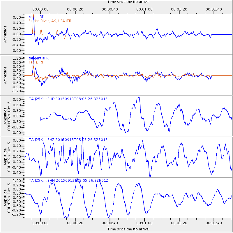
J25K Salcha River, AK, USA - Earthquake Result Viewer
*The percent match for this event was below the threshold and hence no stack was calculated.
| Earthquake location: |
Gulf Of California |
| Earthquake latitude/longitude: |
25.1/-109.2 |
| Earthquake time(UTC): |
2015/09/13 (256) 07:57:38 GMT |
| Earthquake Depth: |
10 km |
| Earthquake Magnitude: |
5.6 MWW, 5.5 MWB, 5.6 MWC |
| Earthquake Catalog/Contributor: |
NEIC PDE/NEIC COMCAT |
|
| Network: |
TA USArray Transportable Network (new EarthScope stations) |
| Station: |
J25K Salcha River, AK, USA |
| Lat/Lon: |
64.61 N/145.37 W |
| Elevation: |
949 m |
|
| Distance: |
45.8 deg |
| Az: |
339.229 deg |
| Baz: |
131.783 deg |
| Ray Param: |
$rayparam |
*The percent match for this event was below the threshold and hence was not used in the summary stack. |
|
| Radial Match: |
67.358604 % |
| Radial Bump: |
369 |
| Transverse Match: |
36.7109 % |
| Transverse Bump: |
360 |
| SOD ConfigId: |
7422571 |
| Insert Time: |
2019-04-20 18:36:30.885 +0000 |
| GWidth: |
2.5 |
| Max Bumps: |
400 |
| Tol: |
0.001 |
|
Signal To Noise
| Channel | StoN | STA | LTA |
| TA:J25K: :BHZ:20150913T08:05:26.32501Z | 4.7238655 | 3.93033E-7 | 8.3201556E-8 |
| TA:J25K: :BHN:20150913T08:05:26.32501Z | 3.0028372 | 6.194519E-7 | 2.0628887E-7 |
| TA:J25K: :BHE:20150913T08:05:26.32501Z | 2.6718154 | 4.3658866E-7 | 1.6340526E-7 |
| Arrivals |
| Ps | |
| PpPs | |
| PsPs/PpSs | |


