You are here: Home > Network List > TA - USArray Transportable Network (new EarthScope stations) Stations List
> Station L19K White Mountain, AK, USA > Earthquake Result Viewer
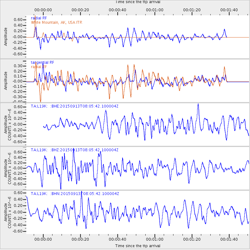
L19K White Mountain, AK, USA - Earthquake Result Viewer
*The percent match for this event was below the threshold and hence no stack was calculated.
| Earthquake location: |
Gulf Of California |
| Earthquake latitude/longitude: |
25.1/-109.2 |
| Earthquake time(UTC): |
2015/09/13 (256) 07:57:38 GMT |
| Earthquake Depth: |
10 km |
| Earthquake Magnitude: |
5.6 MWW, 5.5 MWB, 5.6 MWC |
| Earthquake Catalog/Contributor: |
NEIC PDE/NEIC COMCAT |
|
| Network: |
TA USArray Transportable Network (new EarthScope stations) |
| Station: |
L19K White Mountain, AK, USA |
| Lat/Lon: |
62.18 N/154.85 W |
| Elevation: |
650 m |
|
| Distance: |
47.9 deg |
| Az: |
333.122 deg |
| Baz: |
119.132 deg |
| Ray Param: |
$rayparam |
*The percent match for this event was below the threshold and hence was not used in the summary stack. |
|
| Radial Match: |
62.308285 % |
| Radial Bump: |
400 |
| Transverse Match: |
46.471397 % |
| Transverse Bump: |
400 |
| SOD ConfigId: |
7422571 |
| Insert Time: |
2019-04-20 18:36:35.105 +0000 |
| GWidth: |
2.5 |
| Max Bumps: |
400 |
| Tol: |
0.001 |
|
Signal To Noise
| Channel | StoN | STA | LTA |
| TA:L19K: :BHZ:20150913T08:05:42.100004Z | 3.5999975 | 3.2480108E-7 | 9.0222585E-8 |
| TA:L19K: :BHN:20150913T08:05:42.100004Z | 0.6248692 | 1.1862893E-7 | 1.8984602E-7 |
| TA:L19K: :BHE:20150913T08:05:42.100004Z | 3.4760253 | 2.9147117E-7 | 8.385186E-8 |
| Arrivals |
| Ps | |
| PpPs | |
| PsPs/PpSs | |


