You are here: Home > Network List > CN - Canadian National Seismograph Network Stations List
> Station FRB IQALUIT, N.W.T. > Earthquake Result Viewer
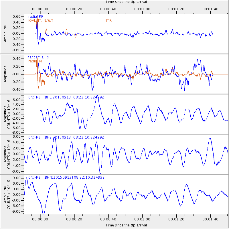
FRB IQALUIT, N.W.T. - Earthquake Result Viewer
*The percent match for this event was below the threshold and hence no stack was calculated.
| Earthquake location: |
Gulf Of California |
| Earthquake latitude/longitude: |
25.2/-109.4 |
| Earthquake time(UTC): |
2015/09/13 (256) 08:14:12 GMT |
| Earthquake Depth: |
10 km |
| Earthquake Magnitude: |
6.6 MWP, 6.8 MI |
| Earthquake Catalog/Contributor: |
NEIC PDE/NEIC COMCAT |
|
| Network: |
CN Canadian National Seismograph Network |
| Station: |
FRB IQALUIT, N.W.T. |
| Lat/Lon: |
63.75 N/68.55 W |
| Elevation: |
18 m |
|
| Distance: |
46.9 deg |
| Az: |
23.478 deg |
| Baz: |
234.275 deg |
| Ray Param: |
$rayparam |
*The percent match for this event was below the threshold and hence was not used in the summary stack. |
|
| Radial Match: |
75.08096 % |
| Radial Bump: |
400 |
| Transverse Match: |
26.908249 % |
| Transverse Bump: |
331 |
| SOD ConfigId: |
7422571 |
| Insert Time: |
2019-04-20 18:38:36.888 +0000 |
| GWidth: |
2.5 |
| Max Bumps: |
400 |
| Tol: |
0.001 |
|
Signal To Noise
| Channel | StoN | STA | LTA |
| CN:FRB: :BHZ:20150913T08:22:10.32499Z | 1.0953982 | 1.6200793E-6 | 1.4789866E-6 |
| CN:FRB: :BHN:20150913T08:22:10.32499Z | 1.6319631 | 6.425912E-6 | 3.937535E-6 |
| CN:FRB: :BHE:20150913T08:22:10.32499Z | 1.7880714 | 4.9480163E-6 | 2.7672363E-6 |
| Arrivals |
| Ps | |
| PpPs | |
| PsPs/PpSs | |


