You are here: Home > Network List > TA - USArray Transportable Network (new EarthScope stations) Stations List
> Station I23K Minto, Yukon-Koyukuk, AK, USA > Earthquake Result Viewer
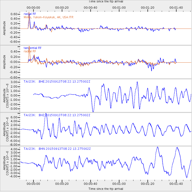
I23K Minto, Yukon-Koyukuk, AK, USA - Earthquake Result Viewer
*The percent match for this event was below the threshold and hence no stack was calculated.
| Earthquake location: |
Gulf Of California |
| Earthquake latitude/longitude: |
25.2/-109.4 |
| Earthquake time(UTC): |
2015/09/13 (256) 08:14:12 GMT |
| Earthquake Depth: |
10 km |
| Earthquake Magnitude: |
6.6 MWP, 6.8 MI |
| Earthquake Catalog/Contributor: |
NEIC PDE/NEIC COMCAT |
|
| Network: |
TA USArray Transportable Network (new EarthScope stations) |
| Station: |
I23K Minto, Yukon-Koyukuk, AK, USA |
| Lat/Lon: |
65.15 N/149.36 W |
| Elevation: |
149 m |
|
| Distance: |
47.4 deg |
| Az: |
338.36 deg |
| Baz: |
127.738 deg |
| Ray Param: |
$rayparam |
*The percent match for this event was below the threshold and hence was not used in the summary stack. |
|
| Radial Match: |
90.17603 % |
| Radial Bump: |
365 |
| Transverse Match: |
63.70596 % |
| Transverse Bump: |
400 |
| SOD ConfigId: |
7422571 |
| Insert Time: |
2019-04-20 18:40:38.028 +0000 |
| GWidth: |
2.5 |
| Max Bumps: |
400 |
| Tol: |
0.001 |
|
Signal To Noise
| Channel | StoN | STA | LTA |
| TA:I23K: :BHZ:20150913T08:22:13.275002Z | 4.551745 | 9.2804635E-7 | 2.0388805E-7 |
| TA:I23K: :BHN:20150913T08:22:13.275002Z | 2.092532 | 4.894471E-7 | 2.3390184E-7 |
| TA:I23K: :BHE:20150913T08:22:13.275002Z | 0.6030302 | 1.9545882E-7 | 3.2412774E-7 |
| Arrivals |
| Ps | |
| PpPs | |
| PsPs/PpSs | |


