You are here: Home > Network List > TA - USArray Transportable Network (new EarthScope stations) Stations List
> Station J26L Joseph Creek, AK, USA > Earthquake Result Viewer
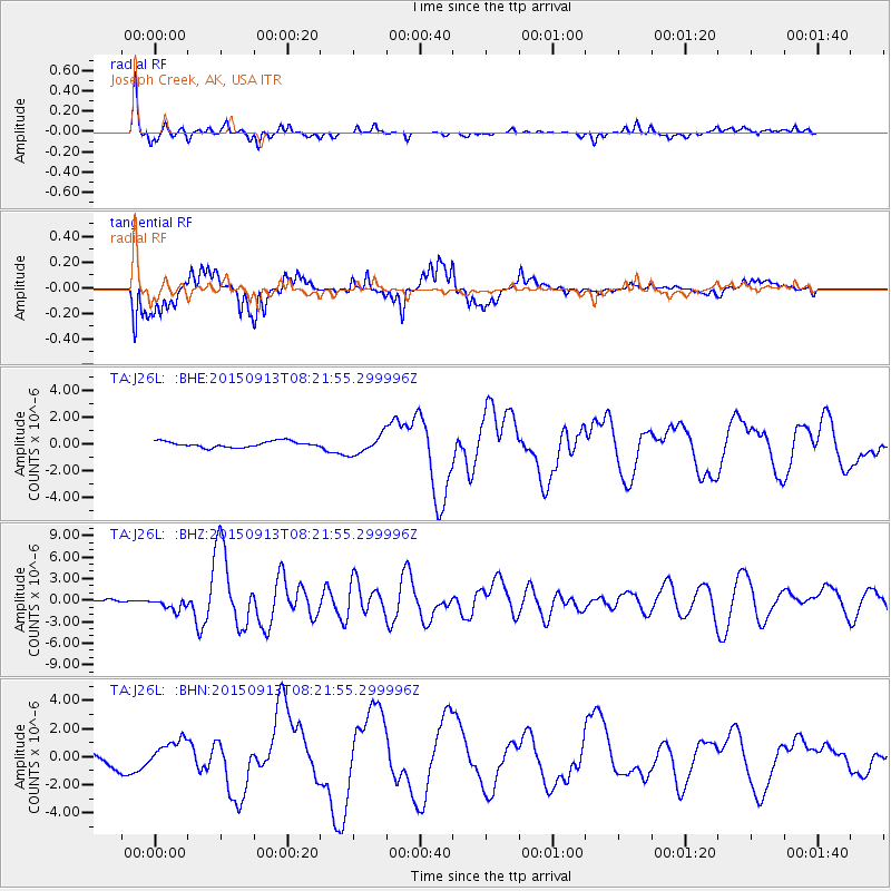
J26L Joseph Creek, AK, USA - Earthquake Result Viewer
*The percent match for this event was below the threshold and hence no stack was calculated.
| Earthquake location: |
Gulf Of California |
| Earthquake latitude/longitude: |
25.2/-109.4 |
| Earthquake time(UTC): |
2015/09/13 (256) 08:14:12 GMT |
| Earthquake Depth: |
10 km |
| Earthquake Magnitude: |
6.6 MWP, 6.8 MI |
| Earthquake Catalog/Contributor: |
NEIC PDE/NEIC COMCAT |
|
| Network: |
TA USArray Transportable Network (new EarthScope stations) |
| Station: |
J26L Joseph Creek, AK, USA |
| Lat/Lon: |
64.50 N/143.56 W |
| Elevation: |
1144 m |
|
| Distance: |
45.1 deg |
| Az: |
339.927 deg |
| Baz: |
134.062 deg |
| Ray Param: |
$rayparam |
*The percent match for this event was below the threshold and hence was not used in the summary stack. |
|
| Radial Match: |
92.02014 % |
| Radial Bump: |
324 |
| Transverse Match: |
74.15582 % |
| Transverse Bump: |
379 |
| SOD ConfigId: |
7422571 |
| Insert Time: |
2019-04-20 18:40:39.960 +0000 |
| GWidth: |
2.5 |
| Max Bumps: |
400 |
| Tol: |
0.001 |
|
Signal To Noise
| Channel | StoN | STA | LTA |
| TA:J26L: :BHZ:20150913T08:21:55.299996Z | 3.695315 | 8.5411824E-7 | 2.3113545E-7 |
| TA:J26L: :BHN:20150913T08:21:55.299996Z | 1.6930484 | 1.0045298E-6 | 5.9332615E-7 |
| TA:J26L: :BHE:20150913T08:21:55.299996Z | 5.105407 | 1.3348683E-6 | 2.6146165E-7 |
| Arrivals |
| Ps | |
| PpPs | |
| PsPs/PpSs | |


