You are here: Home > Network List > AV - Alaska Volcano Observatory Stations List
> Station ILS Iliamna South, Iliamna Volcano, Alaska > Earthquake Result Viewer
ILS Iliamna South, Iliamna Volcano, Alaska - Earthquake Result Viewer
| Earthquake location: |
Northern Molucca Sea |
| Earthquake latitude/longitude: |
1.9/126.4 |
| Earthquake time(UTC): |
2015/09/16 (259) 07:40:59 GMT |
| Earthquake Depth: |
53 km |
| Earthquake Magnitude: |
6.3 MWB |
| Earthquake Catalog/Contributor: |
NEIC PDE/NEIC COMCAT |
|
| Network: |
AV Alaska Volcano Observatory |
| Station: |
ILS Iliamna South, Iliamna Volcano, Alaska |
| Lat/Lon: |
59.96 N/153.07 W |
| Elevation: |
1125 m |
|
| Distance: |
83.7 deg |
| Az: |
29.96 deg |
| Baz: |
262.736 deg |
| Ray Param: |
0.04593176 |
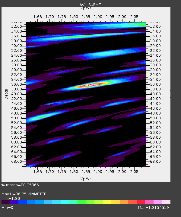
| Estimated Moho Depth: |
36.25 km |
| Estimated Crust Vp/Vs: |
1.86 |
| Assumed Crust Vp: |
5.989 km/s |
| Estimated Crust Vs: |
3.22 km/s |
| Estimated Crust Poisson's Ratio: |
0.30 |
|
| Radial Match: |
88.25066 % |
| Radial Bump: |
400 |
| Transverse Match: |
81.32062 % |
| Transverse Bump: |
400 |
| SOD ConfigId: |
7422571 |
| Insert Time: |
2019-04-20 18:43:12.297 +0000 |
| GWidth: |
2.5 |
| Max Bumps: |
400 |
| Tol: |
0.001 |
|
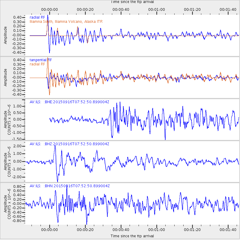
Signal To Noise
| Channel | StoN | STA | LTA |
| AV:ILS: :BHZ:20150916T07:52:50.899004Z | 12.996025 | 1.1719362E-6 | 9.017652E-8 |
| AV:ILS: :BHN:20150916T07:52:50.899004Z | 3.7333684 | 3.5095755E-7 | 9.400561E-8 |
| AV:ILS: :BHE:20150916T07:52:50.899004Z | 5.2160482 | 5.631789E-7 | 1.07970415E-7 |
| Arrivals |
| Ps | 5.3 SECOND |
| PpPs | 17 SECOND |
| PsPs/PpSs | 22 SECOND |


