You are here: Home > Network List > CN - Canadian National Seismograph Network Stations List
> Station INK INUVIK, NT > Earthquake Result Viewer
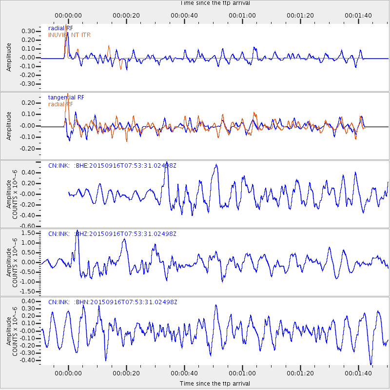
INK INUVIK, NT - Earthquake Result Viewer
*The percent match for this event was below the threshold and hence no stack was calculated.
| Earthquake location: |
Northern Molucca Sea |
| Earthquake latitude/longitude: |
1.9/126.4 |
| Earthquake time(UTC): |
2015/09/16 (259) 07:40:59 GMT |
| Earthquake Depth: |
53 km |
| Earthquake Magnitude: |
6.3 MWB |
| Earthquake Catalog/Contributor: |
NEIC PDE/NEIC COMCAT |
|
| Network: |
CN Canadian National Seismograph Network |
| Station: |
INK INUVIK, NT |
| Lat/Lon: |
68.31 N/133.53 W |
| Elevation: |
44 m |
|
| Distance: |
92.0 deg |
| Az: |
21.485 deg |
| Baz: |
280.06 deg |
| Ray Param: |
$rayparam |
*The percent match for this event was below the threshold and hence was not used in the summary stack. |
|
| Radial Match: |
71.43206 % |
| Radial Bump: |
400 |
| Transverse Match: |
57.77953 % |
| Transverse Bump: |
400 |
| SOD ConfigId: |
7422571 |
| Insert Time: |
2019-04-20 18:43:48.721 +0000 |
| GWidth: |
2.5 |
| Max Bumps: |
400 |
| Tol: |
0.001 |
|
Signal To Noise
| Channel | StoN | STA | LTA |
| CN:INK: :BHZ:20150916T07:53:31.02498Z | 6.571175 | 7.364409E-7 | 1.1207141E-7 |
| CN:INK: :BHN:20150916T07:53:31.02498Z | 1.8892581 | 2.0265226E-7 | 1.07265514E-7 |
| CN:INK: :BHE:20150916T07:53:31.02498Z | 3.512244 | 2.9073854E-7 | 8.277857E-8 |
| Arrivals |
| Ps | |
| PpPs | |
| PsPs/PpSs | |


