You are here: Home > Network List > KO - Kandilli Observatory Digital Broadband Seismic Network Stations List
> Station BALB Balikesir-Turkiye > Earthquake Result Viewer
BALB Balikesir-Turkiye - Earthquake Result Viewer
| Earthquake location: |
Northern Molucca Sea |
| Earthquake latitude/longitude: |
1.9/126.4 |
| Earthquake time(UTC): |
2015/09/16 (259) 07:40:59 GMT |
| Earthquake Depth: |
53 km |
| Earthquake Magnitude: |
6.3 MWB |
| Earthquake Catalog/Contributor: |
NEIC PDE/NEIC COMCAT |
|
| Network: |
KO Kandilli Observatory Digital Broadband Seismic Network |
| Station: |
BALB Balikesir-Turkiye |
| Lat/Lon: |
39.64 N/27.88 E |
| Elevation: |
120 m |
|
| Distance: |
95.4 deg |
| Az: |
309.909 deg |
| Baz: |
83.155 deg |
| Ray Param: |
0.04076842 |
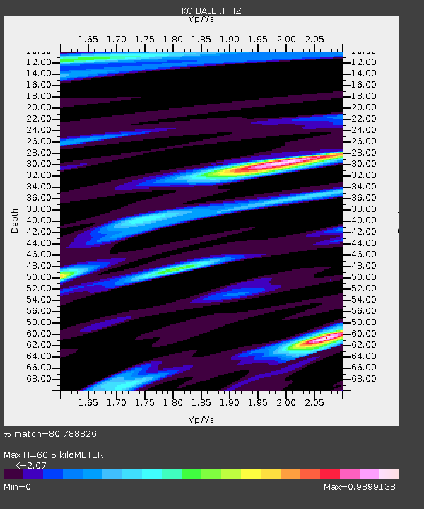
| Estimated Moho Depth: |
60.5 km |
| Estimated Crust Vp/Vs: |
2.07 |
| Assumed Crust Vp: |
6.155 km/s |
| Estimated Crust Vs: |
2.973 km/s |
| Estimated Crust Poisson's Ratio: |
0.35 |
|
| Radial Match: |
80.788826 % |
| Radial Bump: |
400 |
| Transverse Match: |
72.411316 % |
| Transverse Bump: |
400 |
| SOD ConfigId: |
7422571 |
| Insert Time: |
2019-04-20 18:44:40.741 +0000 |
| GWidth: |
2.5 |
| Max Bumps: |
400 |
| Tol: |
0.001 |
|

Signal To Noise
| Channel | StoN | STA | LTA |
| KO:BALB: :HHZ:20150916T07:53:46.630022Z | 4.5488915 | 5.590746E-7 | 1.2290347E-7 |
| KO:BALB: :HHN:20150916T07:53:46.630022Z | 0.8718953 | 1.5055079E-7 | 1.7267071E-7 |
| KO:BALB: :HHE:20150916T07:53:46.630022Z | 1.1152352 | 1.7689236E-7 | 1.586144E-7 |
| Arrivals |
| Ps | 11 SECOND |
| PpPs | 30 SECOND |
| PsPs/PpSs | 40 SECOND |


