You are here: Home > Network List > KZ - Kazakhstan Network Stations List
> Station MAKZ Makanchi, Kazakstan > Earthquake Result Viewer
MAKZ Makanchi, Kazakstan - Earthquake Result Viewer
| Earthquake location: |
Northern Molucca Sea |
| Earthquake latitude/longitude: |
1.9/126.4 |
| Earthquake time(UTC): |
2015/09/16 (259) 07:40:59 GMT |
| Earthquake Depth: |
53 km |
| Earthquake Magnitude: |
6.3 MWB |
| Earthquake Catalog/Contributor: |
NEIC PDE/NEIC COMCAT |
|
| Network: |
KZ Kazakhstan Network |
| Station: |
MAKZ Makanchi, Kazakstan |
| Lat/Lon: |
46.81 N/81.98 E |
| Elevation: |
600 m |
|
| Distance: |
59.1 deg |
| Az: |
325.929 deg |
| Baz: |
125.395 deg |
| Ray Param: |
0.062299233 |
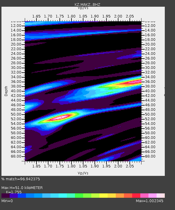
| Estimated Moho Depth: |
51.0 km |
| Estimated Crust Vp/Vs: |
1.75 |
| Assumed Crust Vp: |
6.571 km/s |
| Estimated Crust Vs: |
3.744 km/s |
| Estimated Crust Poisson's Ratio: |
0.26 |
|
| Radial Match: |
96.942375 % |
| Radial Bump: |
326 |
| Transverse Match: |
90.43511 % |
| Transverse Bump: |
400 |
| SOD ConfigId: |
7422571 |
| Insert Time: |
2019-04-20 18:44:57.985 +0000 |
| GWidth: |
2.5 |
| Max Bumps: |
400 |
| Tol: |
0.001 |
|

Signal To Noise
| Channel | StoN | STA | LTA |
| KZ:MAKZ: :BHZ:20150916T07:50:23.39998Z | 13.807794 | 7.204134E-7 | 5.2174403E-8 |
| KZ:MAKZ: :BHN:20150916T07:50:23.39998Z | 8.308558 | 1.8621229E-7 | 2.2412106E-8 |
| KZ:MAKZ: :BHE:20150916T07:50:23.39998Z | 11.60453 | 2.9584788E-7 | 2.5494172E-8 |
| Arrivals |
| Ps | 6.2 SECOND |
| PpPs | 20 SECOND |
| PsPs/PpSs | 26 SECOND |


