You are here: Home > Network List > ND - New CaleDonia Broadband Seismic Network Stations List
> Station KOUNC Koumac, New Caledonia > Earthquake Result Viewer
KOUNC Koumac, New Caledonia - Earthquake Result Viewer

| Earthquake location: |
Northern Molucca Sea |
| Earthquake latitude/longitude: |
1.9/126.4 |
| Earthquake time(UTC): |
2015/09/16 (259) 07:40:59 GMT |
| Earthquake Depth: |
53 km |
| Earthquake Magnitude: |
6.3 MWB |
| Earthquake Catalog/Contributor: |
NEIC PDE/NEIC COMCAT |
|
| Network: |
ND New CaleDonia Broadband Seismic Network |
| Station: |
KOUNC Koumac, New Caledonia |
| Lat/Lon: |
20.55 S/164.29 E |
| Elevation: |
88 m |
|
| Distance: |
43.3 deg |
| Az: |
122.905 deg |
| Baz: |
296.436 deg |
| Ray Param: |
0.07249588 |
| Estimated Moho Depth: |
19.25 km |
| Estimated Crust Vp/Vs: |
1.67 |
| Assumed Crust Vp: |
5.14 km/s |
| Estimated Crust Vs: |
3.078 km/s |
| Estimated Crust Poisson's Ratio: |
0.22 |
|
| Radial Match: |
81.24342 % |
| Radial Bump: |
400 |
| Transverse Match: |
71.96179 % |
| Transverse Bump: |
400 |
| SOD ConfigId: |
7422571 |
| Insert Time: |
2019-04-20 18:45:02.579 +0000 |
| GWidth: |
2.5 |
| Max Bumps: |
400 |
| Tol: |
0.001 |
|
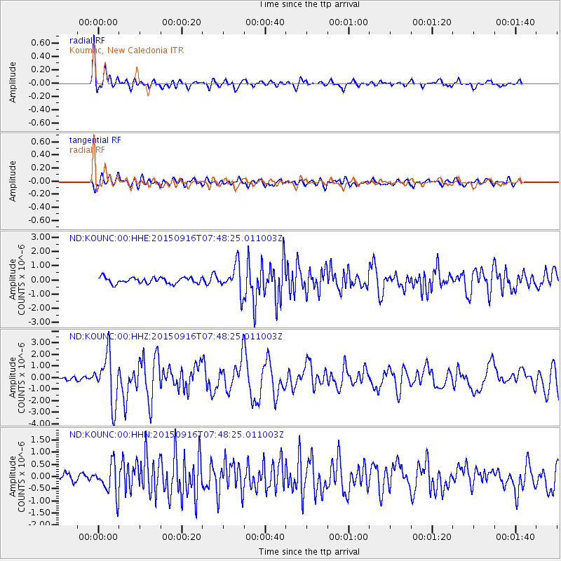
Signal To Noise
| Channel | StoN | STA | LTA |
| ND:KOUNC:00:HHZ:20150916T07:48:25.011003Z | 7.259365 | 2.1495766E-6 | 2.9611084E-7 |
| ND:KOUNC:00:HHN:20150916T07:48:25.011003Z | 2.3149614 | 6.5804903E-7 | 2.8425916E-7 |
| ND:KOUNC:00:HHE:20150916T07:48:25.011003Z | 5.773383 | 1.1775868E-6 | 2.0396823E-7 |
| Arrivals |
| Ps | 2.6 SECOND |
| PpPs | 9.6 SECOND |
| PsPs/PpSs | 12 SECOND |


