You are here: Home > Network List > TA - USArray Transportable Network (new EarthScope stations) Stations List
> Station A21K Barrow, AK, USA > Earthquake Result Viewer
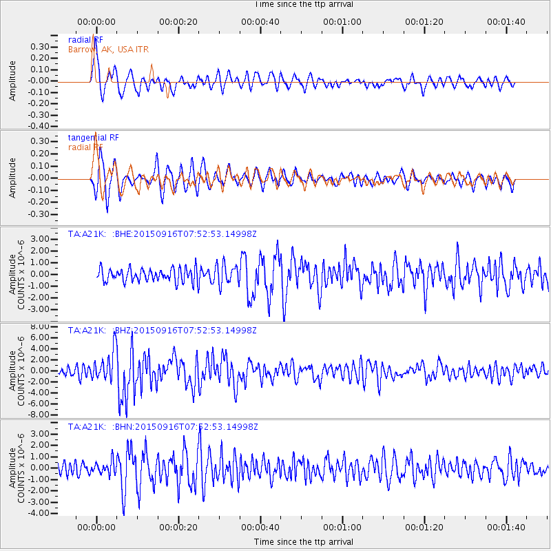
A21K Barrow, AK, USA - Earthquake Result Viewer
*The percent match for this event was below the threshold and hence no stack was calculated.
| Earthquake location: |
Northern Molucca Sea |
| Earthquake latitude/longitude: |
1.9/126.4 |
| Earthquake time(UTC): |
2015/09/16 (259) 07:40:59 GMT |
| Earthquake Depth: |
53 km |
| Earthquake Magnitude: |
6.3 MWB |
| Earthquake Catalog/Contributor: |
NEIC PDE/NEIC COMCAT |
|
| Network: |
TA USArray Transportable Network (new EarthScope stations) |
| Station: |
A21K Barrow, AK, USA |
| Lat/Lon: |
71.32 N/156.62 W |
| Elevation: |
577 m |
|
| Distance: |
84.1 deg |
| Az: |
18.397 deg |
| Baz: |
258.256 deg |
| Ray Param: |
$rayparam |
*The percent match for this event was below the threshold and hence was not used in the summary stack. |
|
| Radial Match: |
79.136116 % |
| Radial Bump: |
400 |
| Transverse Match: |
76.891106 % |
| Transverse Bump: |
400 |
| SOD ConfigId: |
7422571 |
| Insert Time: |
2019-04-20 18:45:35.768 +0000 |
| GWidth: |
2.5 |
| Max Bumps: |
400 |
| Tol: |
0.001 |
|
Signal To Noise
| Channel | StoN | STA | LTA |
| TA:A21K: :BHZ:20150916T07:52:53.14998Z | 4.4568944 | 2.944139E-6 | 6.6058084E-7 |
| TA:A21K: :BHN:20150916T07:52:53.14998Z | 0.8548641 | 5.6044405E-7 | 6.555943E-7 |
| TA:A21K: :BHE:20150916T07:52:53.14998Z | 1.7576877 | 9.803355E-7 | 5.5774154E-7 |
| Arrivals |
| Ps | |
| PpPs | |
| PsPs/PpSs | |


