You are here: Home > Network List > TA - USArray Transportable Network (new EarthScope stations) Stations List
> Station H24K Noodor Dome, AK, USA > Earthquake Result Viewer
H24K Noodor Dome, AK, USA - Earthquake Result Viewer
| Earthquake location: |
Northern Molucca Sea |
| Earthquake latitude/longitude: |
1.9/126.4 |
| Earthquake time(UTC): |
2015/09/16 (259) 07:40:59 GMT |
| Earthquake Depth: |
53 km |
| Earthquake Magnitude: |
6.3 MWB |
| Earthquake Catalog/Contributor: |
NEIC PDE/NEIC COMCAT |
|
| Network: |
TA USArray Transportable Network (new EarthScope stations) |
| Station: |
H24K Noodor Dome, AK, USA |
| Lat/Lon: |
65.84 N/147.88 W |
| Elevation: |
814 m |
|
| Distance: |
86.6 deg |
| Az: |
24.282 deg |
| Baz: |
266.875 deg |
| Ray Param: |
0.04386383 |
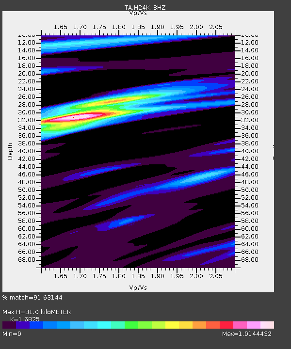
| Estimated Moho Depth: |
31.0 km |
| Estimated Crust Vp/Vs: |
1.68 |
| Assumed Crust Vp: |
6.566 km/s |
| Estimated Crust Vs: |
3.903 km/s |
| Estimated Crust Poisson's Ratio: |
0.23 |
|
| Radial Match: |
91.63144 % |
| Radial Bump: |
400 |
| Transverse Match: |
89.021065 % |
| Transverse Bump: |
400 |
| SOD ConfigId: |
7422571 |
| Insert Time: |
2019-04-20 18:45:40.743 +0000 |
| GWidth: |
2.5 |
| Max Bumps: |
400 |
| Tol: |
0.001 |
|

Signal To Noise
| Channel | StoN | STA | LTA |
| TA:H24K: :BHZ:20150916T07:53:05.425005Z | 14.861443 | 1.2504955E-6 | 8.414362E-8 |
| TA:H24K: :BHN:20150916T07:53:05.425005Z | 1.7248204 | 1.1941344E-7 | 6.923239E-8 |
| TA:H24K: :BHE:20150916T07:53:05.425005Z | 5.1901827 | 4.1045246E-7 | 7.908247E-8 |
| Arrivals |
| Ps | 3.3 SECOND |
| PpPs | 12 SECOND |
| PsPs/PpSs | 16 SECOND |


