You are here: Home > Network List > KN - Kyrgyz Seismic Telemetry Network Stations List
> Station TKM2 - > Earthquake Result Viewer
TKM2 - - Earthquake Result Viewer
| Earthquake location: |
New Britain Region, P.N.G. |
| Earthquake latitude/longitude: |
-6.0/151.5 |
| Earthquake time(UTC): |
2015/09/16 (259) 14:03:22 GMT |
| Earthquake Depth: |
6.3 km |
| Earthquake Magnitude: |
6.0 MWB |
| Earthquake Catalog/Contributor: |
NEIC PDE/NEIC COMCAT |
|
| Network: |
KN Kyrgyz Seismic Telemetry Network |
| Station: |
TKM2 - |
| Lat/Lon: |
42.92 N/75.60 E |
| Elevation: |
2020 m |
|
| Distance: |
83.8 deg |
| Az: |
314.234 deg |
| Baz: |
104.04 deg |
| Ray Param: |
0.045939043 |
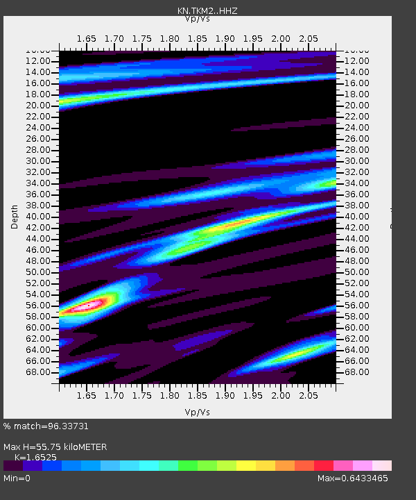
| Estimated Moho Depth: |
55.75 km |
| Estimated Crust Vp/Vs: |
1.65 |
| Assumed Crust Vp: |
6.306 km/s |
| Estimated Crust Vs: |
3.816 km/s |
| Estimated Crust Poisson's Ratio: |
0.21 |
|
| Radial Match: |
96.33731 % |
| Radial Bump: |
255 |
| Transverse Match: |
90.671265 % |
| Transverse Bump: |
269 |
| SOD ConfigId: |
7422571 |
| Insert Time: |
2019-04-20 18:52:06.326 +0000 |
| GWidth: |
2.5 |
| Max Bumps: |
400 |
| Tol: |
0.001 |
|
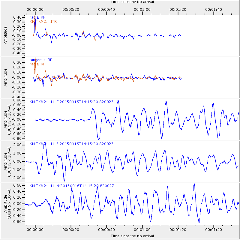
Signal To Noise
| Channel | StoN | STA | LTA |
| KN:TKM2: :HHZ:20150916T14:15:20.82002Z | 25.82375 | 8.781706E-7 | 3.400632E-8 |
| KN:TKM2: :HHN:20150916T14:15:20.82002Z | 1.7749914 | 4.417262E-8 | 2.4886102E-8 |
| KN:TKM2: :HHE:20150916T14:15:20.82002Z | 13.365519 | 2.8195575E-7 | 2.1095758E-8 |
| Arrivals |
| Ps | 5.9 SECOND |
| PpPs | 23 SECOND |
| PsPs/PpSs | 29 SECOND |


