You are here: Home > Network List > TA - USArray Transportable Network (new EarthScope stations) Stations List
> Station H23K Yukon River, AK, USA > Earthquake Result Viewer
H23K Yukon River, AK, USA - Earthquake Result Viewer
| Earthquake location: |
New Britain Region, P.N.G. |
| Earthquake latitude/longitude: |
-6.0/151.5 |
| Earthquake time(UTC): |
2015/09/16 (259) 14:03:22 GMT |
| Earthquake Depth: |
6.3 km |
| Earthquake Magnitude: |
6.0 MWB |
| Earthquake Catalog/Contributor: |
NEIC PDE/NEIC COMCAT |
|
| Network: |
TA USArray Transportable Network (new EarthScope stations) |
| Station: |
H23K Yukon River, AK, USA |
| Lat/Lon: |
65.83 N/149.54 W |
| Elevation: |
617 m |
|
| Distance: |
83.3 deg |
| Az: |
20.819 deg |
| Baz: |
239.136 deg |
| Ray Param: |
0.046278138 |
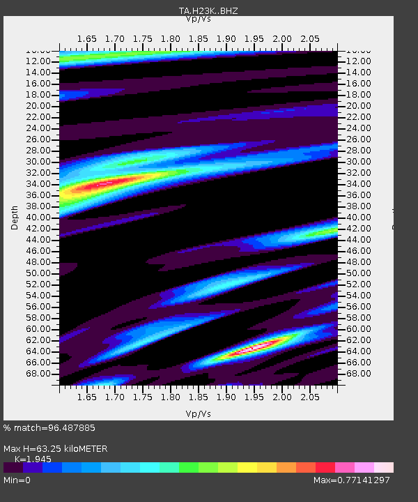
| Estimated Moho Depth: |
63.25 km |
| Estimated Crust Vp/Vs: |
1.95 |
| Assumed Crust Vp: |
6.566 km/s |
| Estimated Crust Vs: |
3.376 km/s |
| Estimated Crust Poisson's Ratio: |
0.32 |
|
| Radial Match: |
96.487885 % |
| Radial Bump: |
318 |
| Transverse Match: |
95.37335 % |
| Transverse Bump: |
400 |
| SOD ConfigId: |
7422571 |
| Insert Time: |
2019-04-20 18:53:34.716 +0000 |
| GWidth: |
2.5 |
| Max Bumps: |
400 |
| Tol: |
0.001 |
|

Signal To Noise
| Channel | StoN | STA | LTA |
| TA:H23K: :BHZ:20150916T14:15:18.274976Z | 29.156885 | 1.8389156E-6 | 6.3069685E-8 |
| TA:H23K: :BHN:20150916T14:15:18.274976Z | 5.853398 | 4.1754893E-7 | 7.1334455E-8 |
| TA:H23K: :BHE:20150916T14:15:18.274976Z | 7.565777 | 4.6266493E-7 | 6.1152335E-8 |
| Arrivals |
| Ps | 9.3 SECOND |
| PpPs | 28 SECOND |
| PsPs/PpSs | 37 SECOND |


