You are here: Home > Network List > TA - USArray Transportable Network (new EarthScope stations) Stations List
> Station J26L Joseph Creek, AK, USA > Earthquake Result Viewer
J26L Joseph Creek, AK, USA - Earthquake Result Viewer
| Earthquake location: |
New Britain Region, P.N.G. |
| Earthquake latitude/longitude: |
-6.0/151.5 |
| Earthquake time(UTC): |
2015/09/16 (259) 14:03:22 GMT |
| Earthquake Depth: |
6.3 km |
| Earthquake Magnitude: |
6.0 MWB |
| Earthquake Catalog/Contributor: |
NEIC PDE/NEIC COMCAT |
|
| Network: |
TA USArray Transportable Network (new EarthScope stations) |
| Station: |
J26L Joseph Creek, AK, USA |
| Lat/Lon: |
64.50 N/143.56 W |
| Elevation: |
1144 m |
|
| Distance: |
84.9 deg |
| Az: |
23.19 deg |
| Baz: |
244.8 deg |
| Ray Param: |
0.045138806 |
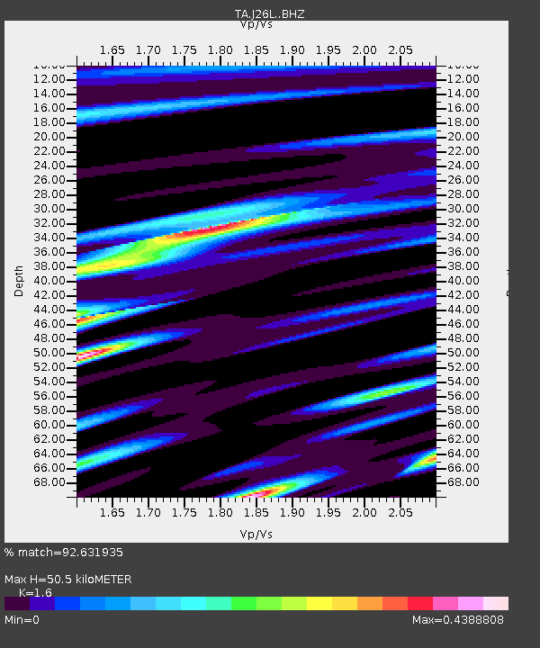
| Estimated Moho Depth: |
50.5 km |
| Estimated Crust Vp/Vs: |
1.60 |
| Assumed Crust Vp: |
6.566 km/s |
| Estimated Crust Vs: |
4.104 km/s |
| Estimated Crust Poisson's Ratio: |
0.18 |
|
| Radial Match: |
92.631935 % |
| Radial Bump: |
326 |
| Transverse Match: |
76.157234 % |
| Transverse Bump: |
400 |
| SOD ConfigId: |
7422571 |
| Insert Time: |
2019-04-20 18:53:43.667 +0000 |
| GWidth: |
2.5 |
| Max Bumps: |
400 |
| Tol: |
0.001 |
|
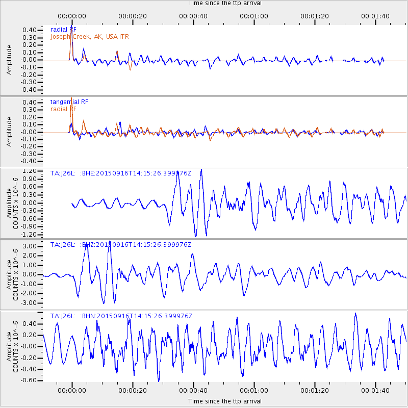
Signal To Noise
| Channel | StoN | STA | LTA |
| TA:J26L: :BHZ:20150916T14:15:26.399976Z | 19.328377 | 1.5313369E-6 | 7.92274E-8 |
| TA:J26L: :BHN:20150916T14:15:26.399976Z | 1.6033239 | 2.0077755E-7 | 1.2522581E-7 |
| TA:J26L: :BHE:20150916T14:15:26.399976Z | 5.013927 | 5.3122363E-7 | 1.0594962E-7 |
| Arrivals |
| Ps | 4.7 SECOND |
| PpPs | 19 SECOND |
| PsPs/PpSs | 24 SECOND |


