You are here: Home > Network List > TA - USArray Transportable Network (new EarthScope stations) Stations List
> Station M26K Nabesna, AK, USA > Earthquake Result Viewer
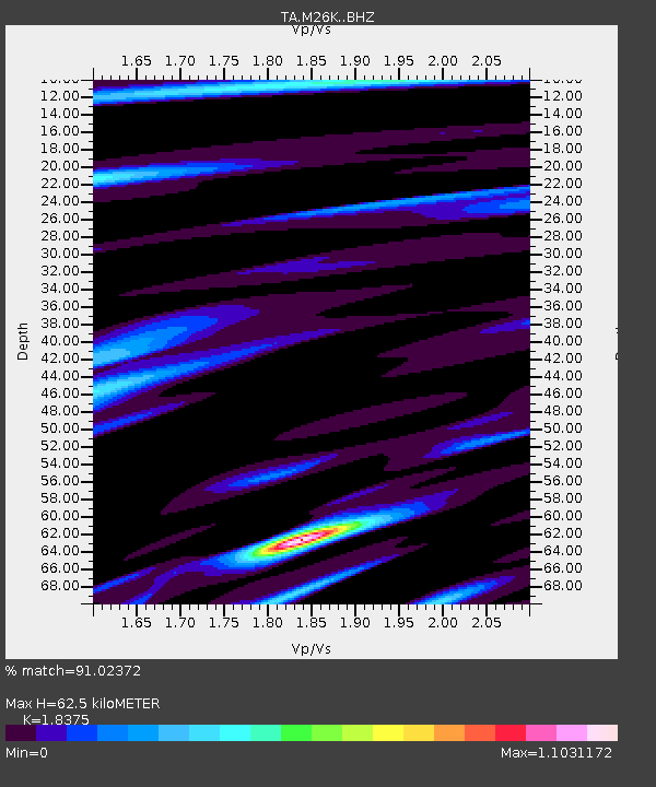
M26K Nabesna, AK, USA - Earthquake Result Viewer
| Earthquake location: |
New Britain Region, P.N.G. |
| Earthquake latitude/longitude: |
-6.0/151.5 |
| Earthquake time(UTC): |
2015/09/16 (259) 14:03:22 GMT |
| Earthquake Depth: |
6.3 km |
| Earthquake Magnitude: |
6.0 MWB |
| Earthquake Catalog/Contributor: |
NEIC PDE/NEIC COMCAT |
|
| Network: |
TA USArray Transportable Network (new EarthScope stations) |
| Station: |
M26K Nabesna, AK, USA |
| Lat/Lon: |
62.40 N/143.00 W |
| Elevation: |
888 m |
|
| Distance: |
84.3 deg |
| Az: |
25.219 deg |
| Baz: |
245.498 deg |
| Ray Param: |
0.045607965 |
| Estimated Moho Depth: |
62.5 km |
| Estimated Crust Vp/Vs: |
1.84 |
| Assumed Crust Vp: |
6.566 km/s |
| Estimated Crust Vs: |
3.573 km/s |
| Estimated Crust Poisson's Ratio: |
0.29 |
|
| Radial Match: |
91.02372 % |
| Radial Bump: |
389 |
| Transverse Match: |
80.55624 % |
| Transverse Bump: |
400 |
| SOD ConfigId: |
7422571 |
| Insert Time: |
2019-04-20 18:53:53.055 +0000 |
| GWidth: |
2.5 |
| Max Bumps: |
400 |
| Tol: |
0.001 |
|

Signal To Noise
| Channel | StoN | STA | LTA |
| TA:M26K: :BHZ:20150916T14:15:23.099988Z | 10.233529 | 1.3996871E-6 | 1.3677462E-7 |
| TA:M26K: :BHN:20150916T14:15:23.099988Z | 2.669625 | 3.9783635E-7 | 1.490233E-7 |
| TA:M26K: :BHE:20150916T14:15:23.099988Z | 3.5868244 | 4.2560168E-7 | 1.1865696E-7 |
| Arrivals |
| Ps | 8.2 SECOND |
| PpPs | 26 SECOND |
| PsPs/PpSs | 35 SECOND |


