You are here: Home > Network List > TA - USArray Transportable Network (new EarthScope stations) Stations List
> Station N25K Chitina, Valdez-Cordova, AK, USA > Earthquake Result Viewer
N25K Chitina, Valdez-Cordova, AK, USA - Earthquake Result Viewer
| Earthquake location: |
New Britain Region, P.N.G. |
| Earthquake latitude/longitude: |
-6.0/151.5 |
| Earthquake time(UTC): |
2015/09/16 (259) 14:03:22 GMT |
| Earthquake Depth: |
6.3 km |
| Earthquake Magnitude: |
6.0 MWB |
| Earthquake Catalog/Contributor: |
NEIC PDE/NEIC COMCAT |
|
| Network: |
TA USArray Transportable Network (new EarthScope stations) |
| Station: |
N25K Chitina, Valdez-Cordova, AK, USA |
| Lat/Lon: |
61.61 N/144.60 W |
| Elevation: |
1087 m |
|
| Distance: |
83.2 deg |
| Az: |
25.622 deg |
| Baz: |
244.129 deg |
| Ray Param: |
0.046330784 |
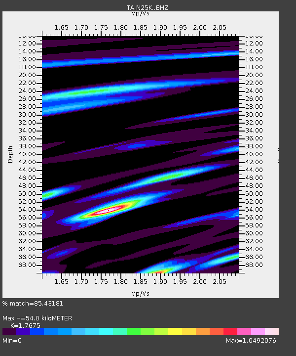
| Estimated Moho Depth: |
54.0 km |
| Estimated Crust Vp/Vs: |
1.77 |
| Assumed Crust Vp: |
6.566 km/s |
| Estimated Crust Vs: |
3.715 km/s |
| Estimated Crust Poisson's Ratio: |
0.26 |
|
| Radial Match: |
85.43181 % |
| Radial Bump: |
400 |
| Transverse Match: |
81.052864 % |
| Transverse Bump: |
337 |
| SOD ConfigId: |
7422571 |
| Insert Time: |
2019-04-20 18:53:57.694 +0000 |
| GWidth: |
2.5 |
| Max Bumps: |
400 |
| Tol: |
0.001 |
|

Signal To Noise
| Channel | StoN | STA | LTA |
| TA:N25K: :BHZ:20150916T14:15:17.875012Z | 7.075564 | 1.2745473E-6 | 1.8013368E-7 |
| TA:N25K: :BHN:20150916T14:15:17.875012Z | 2.7729666 | 3.3882642E-7 | 1.2218914E-7 |
| TA:N25K: :BHE:20150916T14:15:17.875012Z | 3.2129135 | 4.6356712E-7 | 1.4428248E-7 |
| Arrivals |
| Ps | 6.5 SECOND |
| PpPs | 22 SECOND |
| PsPs/PpSs | 29 SECOND |


