You are here: Home > Network List > TA - USArray Transportable Network (new EarthScope stations) Stations List
> Station O18K Koktuh Hills, AK, USA > Earthquake Result Viewer
O18K Koktuh Hills, AK, USA - Earthquake Result Viewer

| Earthquake location: |
New Britain Region, P.N.G. |
| Earthquake latitude/longitude: |
-6.0/151.5 |
| Earthquake time(UTC): |
2015/09/16 (259) 14:03:22 GMT |
| Earthquake Depth: |
6.3 km |
| Earthquake Magnitude: |
6.0 MWB |
| Earthquake Catalog/Contributor: |
NEIC PDE/NEIC COMCAT |
|
| Network: |
TA USArray Transportable Network (new EarthScope stations) |
| Station: |
O18K Koktuh Hills, AK, USA |
| Lat/Lon: |
59.85 N/155.21 W |
| Elevation: |
544 m |
|
| Distance: |
77.9 deg |
| Az: |
24.464 deg |
| Baz: |
234.691 deg |
| Ray Param: |
0.050033484 |
| Estimated Moho Depth: |
39.5 km |
| Estimated Crust Vp/Vs: |
1.65 |
| Assumed Crust Vp: |
6.438 km/s |
| Estimated Crust Vs: |
3.89 km/s |
| Estimated Crust Poisson's Ratio: |
0.21 |
|
| Radial Match: |
88.66937 % |
| Radial Bump: |
400 |
| Transverse Match: |
69.38947 % |
| Transverse Bump: |
400 |
| SOD ConfigId: |
7422571 |
| Insert Time: |
2019-04-20 18:53:59.696 +0000 |
| GWidth: |
2.5 |
| Max Bumps: |
400 |
| Tol: |
0.001 |
|
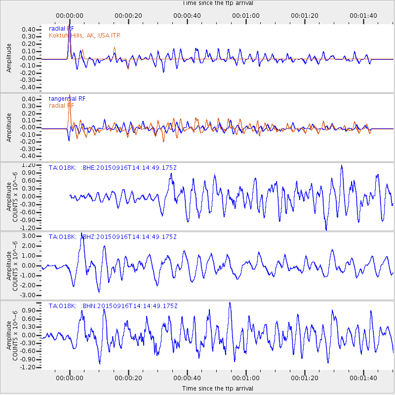
Signal To Noise
| Channel | StoN | STA | LTA |
| TA:O18K: :BHZ:20150916T14:14:49.175Z | 10.904035 | 1.6729454E-6 | 1.5342444E-7 |
| TA:O18K: :BHN:20150916T14:14:49.175Z | 4.7363863 | 4.5347966E-7 | 9.574381E-8 |
| TA:O18K: :BHE:20150916T14:14:49.175Z | 3.3128107 | 4.5392656E-7 | 1.3702159E-7 |
| Arrivals |
| Ps | 4.2 SECOND |
| PpPs | 16 SECOND |
| PsPs/PpSs | 20 SECOND |


