You are here: Home > Network List > IU - Global Seismograph Network (GSN - IRIS/USGS) Stations List
> Station MAKZ Makanchi, Kazakhstan > Earthquake Result Viewer
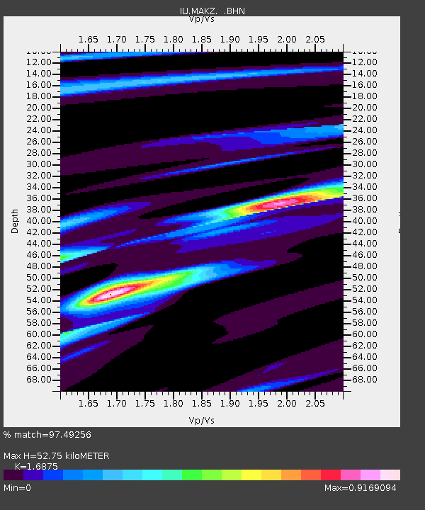
MAKZ Makanchi, Kazakhstan - Earthquake Result Viewer
| Earthquake location: |
Mindanao, Philippines |
| Earthquake latitude/longitude: |
9.5/126.3 |
| Earthquake time(UTC): |
1996/09/20 (264) 04:10:27 GMT |
| Earthquake Depth: |
33 km |
| Earthquake Magnitude: |
5.8 MB, 6.4 MS, 6.6 UNKNOWN, 6.6 MW |
| Earthquake Catalog/Contributor: |
WHDF/NEIC |
|
| Network: |
IU Global Seismograph Network (GSN - IRIS/USGS) |
| Station: |
MAKZ Makanchi, Kazakhstan |
| Lat/Lon: |
46.81 N/81.98 E |
| Elevation: |
600 m |
|
| Distance: |
52.9 deg |
| Az: |
323.001 deg |
| Baz: |
120.189 deg |
| Ray Param: |
0.06641881 |
| Estimated Moho Depth: |
52.75 km |
| Estimated Crust Vp/Vs: |
1.69 |
| Assumed Crust Vp: |
6.571 km/s |
| Estimated Crust Vs: |
3.894 km/s |
| Estimated Crust Poisson's Ratio: |
0.23 |
|
| Radial Match: |
97.49256 % |
| Radial Bump: |
314 |
| Transverse Match: |
93.248795 % |
| Transverse Bump: |
400 |
| SOD ConfigId: |
6273 |
| Insert Time: |
2010-03-04 19:33:15.585 +0000 |
| GWidth: |
2.5 |
| Max Bumps: |
400 |
| Tol: |
0.001 |
|

Signal To Noise
| Channel | StoN | STA | LTA |
| IU:MAKZ: :BHN:19960920T04:19:09.516016Z | 14.076798 | 4.9949193E-7 | 3.548335E-8 |
| IU:MAKZ: :BHE:19960920T04:19:09.516016Z | 16.383451 | 9.621829E-7 | 5.8728943E-8 |
| IU:MAKZ: :BHZ:19960920T04:19:09.516016Z | 15.092261 | 2.0979821E-6 | 1.3901047E-7 |
| Arrivals |
| Ps | 5.9 SECOND |
| PpPs | 20 SECOND |
| PsPs/PpSs | 26 SECOND |


