You are here: Home > Network List > IU - Global Seismograph Network (GSN - IRIS/USGS) Stations List
> Station MAKZ Makanchi, Kazakhstan > Earthquake Result Viewer
MAKZ Makanchi, Kazakhstan - Earthquake Result Viewer

| Earthquake location: |
Solomon Islands |
| Earthquake latitude/longitude: |
-7.1/155.6 |
| Earthquake time(UTC): |
1996/10/14 (288) 23:26:20 GMT |
| Earthquake Depth: |
24 km |
| Earthquake Magnitude: |
5.9 MB, 6.9 MS, 6.8 UNKNOWN, 6.3 ME |
| Earthquake Catalog/Contributor: |
WHDF/NEIC |
|
| Network: |
IU Global Seismograph Network (GSN - IRIS/USGS) |
| Station: |
MAKZ Makanchi, Kazakhstan |
| Lat/Lon: |
46.81 N/81.98 E |
| Elevation: |
600 m |
|
| Distance: |
84.1 deg |
| Az: |
318.515 deg |
| Baz: |
106.858 deg |
| Ray Param: |
0.045699153 |
| Estimated Moho Depth: |
47.75 km |
| Estimated Crust Vp/Vs: |
1.81 |
| Assumed Crust Vp: |
6.571 km/s |
| Estimated Crust Vs: |
3.63 km/s |
| Estimated Crust Poisson's Ratio: |
0.28 |
|
| Radial Match: |
97.17905 % |
| Radial Bump: |
265 |
| Transverse Match: |
93.4581 % |
| Transverse Bump: |
400 |
| SOD ConfigId: |
6273 |
| Insert Time: |
2010-03-04 19:33:16.768 +0000 |
| GWidth: |
2.5 |
| Max Bumps: |
400 |
| Tol: |
0.001 |
|
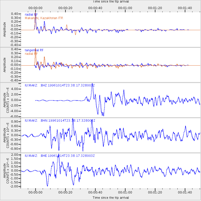
Signal To Noise
| Channel | StoN | STA | LTA |
| IU:MAKZ: :BHN:19961014T23:38:17.328003Z | 1.14873 | 7.174836E-8 | 6.245885E-8 |
| IU:MAKZ: :BHE:19961014T23:38:17.328003Z | 2.2368264 | 1.5180441E-7 | 6.786598E-8 |
| IU:MAKZ: :BHZ:19961014T23:38:17.328003Z | 5.4000635 | 5.2585216E-7 | 9.737888E-8 |
| Arrivals |
| Ps | 6.0 SECOND |
| PpPs | 20 SECOND |
| PsPs/PpSs | 26 SECOND |


