You are here: Home > Network List > UW - Pacific Northwest Regional Seismic Network Stations List
> Station HOOD Mt Hood Meadows, OR CREST BB SMO > Earthquake Result Viewer
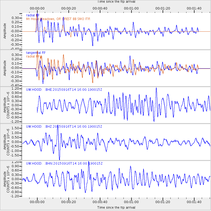
HOOD Mt Hood Meadows, OR CREST BB SMO - Earthquake Result Viewer
*The percent match for this event was below the threshold and hence no stack was calculated.
| Earthquake location: |
New Britain Region, P.N.G. |
| Earthquake latitude/longitude: |
-6.0/151.5 |
| Earthquake time(UTC): |
2015/09/16 (259) 14:03:22 GMT |
| Earthquake Depth: |
6.3 km |
| Earthquake Magnitude: |
6.0 MWB |
| Earthquake Catalog/Contributor: |
NEIC PDE/NEIC COMCAT |
|
| Network: |
UW Pacific Northwest Regional Seismic Network |
| Station: |
HOOD Mt Hood Meadows, OR CREST BB SMO |
| Lat/Lon: |
45.32 N/121.65 W |
| Elevation: |
1520 m |
|
| Distance: |
92.0 deg |
| Az: |
44.823 deg |
| Baz: |
263.596 deg |
| Ray Param: |
$rayparam |
*The percent match for this event was below the threshold and hence was not used in the summary stack. |
|
| Radial Match: |
64.31221 % |
| Radial Bump: |
400 |
| Transverse Match: |
64.33274 % |
| Transverse Bump: |
400 |
| SOD ConfigId: |
7422571 |
| Insert Time: |
2019-04-20 18:54:46.984 +0000 |
| GWidth: |
2.5 |
| Max Bumps: |
400 |
| Tol: |
0.001 |
|
Signal To Noise
| Channel | StoN | STA | LTA |
| UW:HOOD: :BHZ:20150916T14:16:00.190015Z | 3.7642407 | 3.9900013E-7 | 1.059975E-7 |
| UW:HOOD: :BHN:20150916T14:16:00.190015Z | 1.2153621 | 2.3071148E-7 | 1.8982942E-7 |
| UW:HOOD: :BHE:20150916T14:16:00.190015Z | 1.3767557 | 3.9440587E-7 | 2.8647486E-7 |
| Arrivals |
| Ps | |
| PpPs | |
| PsPs/PpSs | |


