You are here: Home > Network List > UW - Pacific Northwest Regional Seismic Network Stations List
> Station MRBL Marblemount, WA, USA > Earthquake Result Viewer
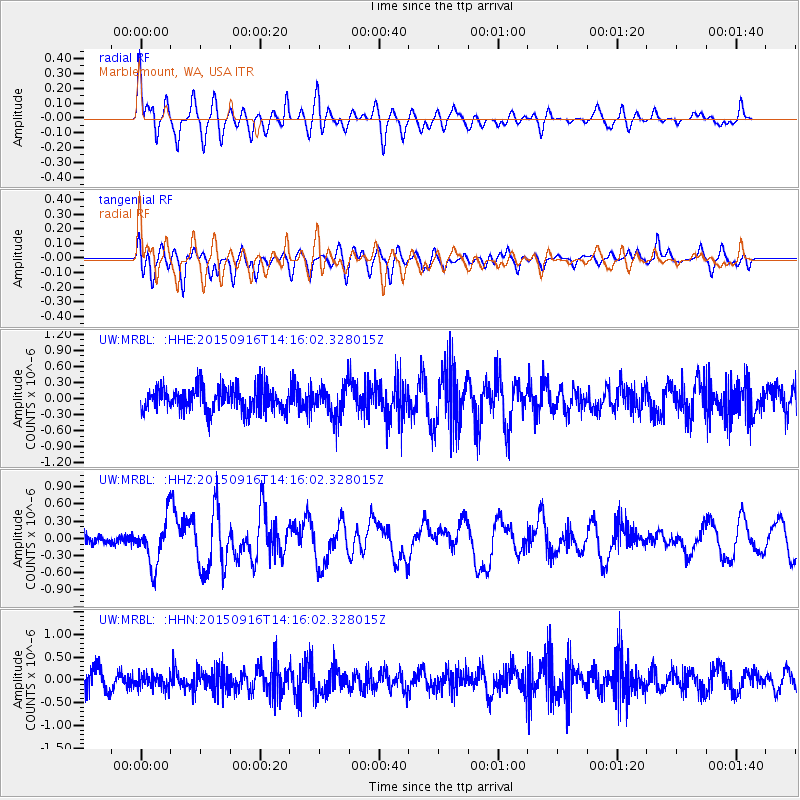
MRBL Marblemount, WA, USA - Earthquake Result Viewer
*The percent match for this event was below the threshold and hence no stack was calculated.
| Earthquake location: |
New Britain Region, P.N.G. |
| Earthquake latitude/longitude: |
-6.0/151.5 |
| Earthquake time(UTC): |
2015/09/16 (259) 14:03:22 GMT |
| Earthquake Depth: |
6.3 km |
| Earthquake Magnitude: |
6.0 MWB |
| Earthquake Catalog/Contributor: |
NEIC PDE/NEIC COMCAT |
|
| Network: |
UW Pacific Northwest Regional Seismic Network |
| Station: |
MRBL Marblemount, WA, USA |
| Lat/Lon: |
48.52 N/121.48 W |
| Elevation: |
75 m |
|
| Distance: |
92.5 deg |
| Az: |
41.654 deg |
| Baz: |
263.844 deg |
| Ray Param: |
$rayparam |
*The percent match for this event was below the threshold and hence was not used in the summary stack. |
|
| Radial Match: |
69.76115 % |
| Radial Bump: |
400 |
| Transverse Match: |
59.51002 % |
| Transverse Bump: |
400 |
| SOD ConfigId: |
7422571 |
| Insert Time: |
2019-04-20 18:54:51.765 +0000 |
| GWidth: |
2.5 |
| Max Bumps: |
400 |
| Tol: |
0.001 |
|
Signal To Noise
| Channel | StoN | STA | LTA |
| UW:MRBL: :HHZ:20150916T14:16:02.328015Z | 5.0160494 | 3.981911E-7 | 7.938341E-8 |
| UW:MRBL: :HHN:20150916T14:16:02.328015Z | 0.7188133 | 1.4413135E-7 | 2.0051291E-7 |
| UW:MRBL: :HHE:20150916T14:16:02.328015Z | 1.3115528 | 2.9695073E-7 | 2.2641157E-7 |
| Arrivals |
| Ps | |
| PpPs | |
| PsPs/PpSs | |


