You are here: Home > Network List > 7A - Mid-Atlantic Geophysical Integrative Collaboration Stations List
> Station LBDL Montpelier, Virginia USA > Earthquake Result Viewer
LBDL Montpelier, Virginia USA - Earthquake Result Viewer
| Earthquake location: |
Near Coast Of Central Chile |
| Earthquake latitude/longitude: |
-31.6/-71.8 |
| Earthquake time(UTC): |
2015/09/16 (259) 22:54:31 GMT |
| Earthquake Depth: |
12 km |
| Earthquake Magnitude: |
8.3 MWW, 7.9 MI |
| Earthquake Catalog/Contributor: |
NEIC PDE/NEIC COMCAT |
|
| Network: |
7A Mid-Atlantic Geophysical Integrative Collaboration |
| Station: |
LBDL Montpelier, Virginia USA |
| Lat/Lon: |
37.80 N/77.64 W |
| Elevation: |
48 m |
|
| Distance: |
69.2 deg |
| Az: |
355.015 deg |
| Baz: |
174.628 deg |
| Ray Param: |
0.055771984 |
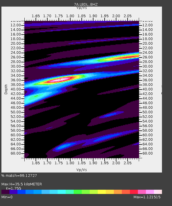
| Estimated Moho Depth: |
35.5 km |
| Estimated Crust Vp/Vs: |
1.75 |
| Assumed Crust Vp: |
6.565 km/s |
| Estimated Crust Vs: |
3.74 km/s |
| Estimated Crust Poisson's Ratio: |
0.26 |
|
| Radial Match: |
99.12727 % |
| Radial Bump: |
210 |
| Transverse Match: |
97.329315 % |
| Transverse Bump: |
400 |
| SOD ConfigId: |
7422571 |
| Insert Time: |
2019-04-20 18:57:46.452 +0000 |
| GWidth: |
2.5 |
| Max Bumps: |
400 |
| Tol: |
0.001 |
|

Signal To Noise
| Channel | StoN | STA | LTA |
| 7A:LBDL: :BHZ:20150916T23:05:06.790Z | 18.456179 | 3.3511449E-6 | 1.8157306E-7 |
| 7A:LBDL: :BHN:20150916T23:05:06.790Z | 9.398753 | 1.4455101E-6 | 1.5379807E-7 |
| 7A:LBDL: :BHE:20150916T23:05:06.790Z | 3.4208543 | 2.4528322E-7 | 7.170233E-8 |
| Arrivals |
| Ps | 4.2 SECOND |
| PpPs | 14 SECOND |
| PsPs/PpSs | 19 SECOND |


