You are here: Home > Network List > 7A - Mid-Atlantic Geophysical Integrative Collaboration Stations List
> Station NAZF Center Point, West Virginia USA > Earthquake Result Viewer
NAZF Center Point, West Virginia USA - Earthquake Result Viewer
| Earthquake location: |
Near Coast Of Central Chile |
| Earthquake latitude/longitude: |
-31.6/-71.8 |
| Earthquake time(UTC): |
2015/09/16 (259) 22:54:31 GMT |
| Earthquake Depth: |
12 km |
| Earthquake Magnitude: |
8.3 MWW, 7.9 MI |
| Earthquake Catalog/Contributor: |
NEIC PDE/NEIC COMCAT |
|
| Network: |
7A Mid-Atlantic Geophysical Integrative Collaboration |
| Station: |
NAZF Center Point, West Virginia USA |
| Lat/Lon: |
39.38 N/80.64 W |
| Elevation: |
0.0 m |
|
| Distance: |
71.1 deg |
| Az: |
352.728 deg |
| Baz: |
171.987 deg |
| Ray Param: |
0.054550108 |
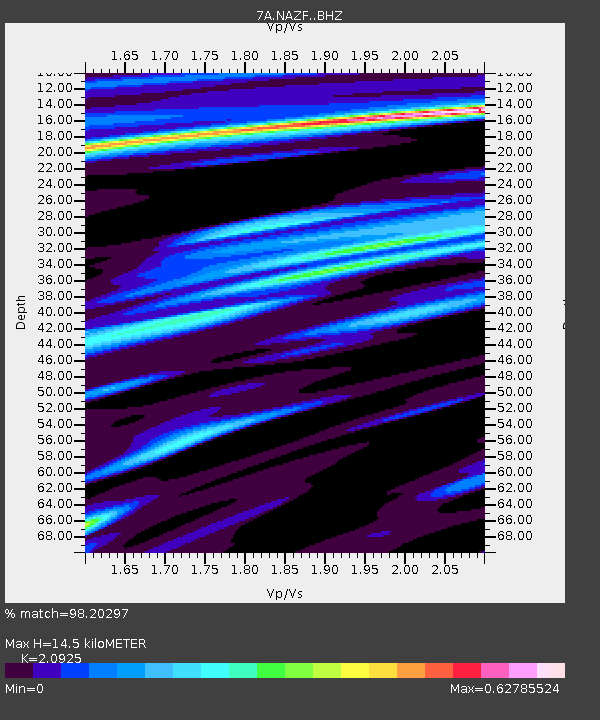
| Estimated Moho Depth: |
14.5 km |
| Estimated Crust Vp/Vs: |
2.09 |
| Assumed Crust Vp: |
6.207 km/s |
| Estimated Crust Vs: |
2.966 km/s |
| Estimated Crust Poisson's Ratio: |
0.35 |
|
| Radial Match: |
98.20297 % |
| Radial Bump: |
368 |
| Transverse Match: |
92.08192 % |
| Transverse Bump: |
400 |
| SOD ConfigId: |
7422571 |
| Insert Time: |
2019-04-20 18:57:49.685 +0000 |
| GWidth: |
2.5 |
| Max Bumps: |
400 |
| Tol: |
0.001 |
|

Signal To Noise
| Channel | StoN | STA | LTA |
| 7A:NAZF: :BHZ:20150916T23:05:18.065024Z | 8.509218 | 2.6449216E-6 | 3.1083016E-7 |
| 7A:NAZF: :BHN:20150916T23:05:18.065024Z | 4.1747675 | 9.77116E-7 | 2.3405278E-7 |
| 7A:NAZF: :BHE:20150916T23:05:18.065024Z | 0.59050786 | 1.969665E-7 | 3.335544E-7 |
| Arrivals |
| Ps | 2.6 SECOND |
| PpPs | 7.0 SECOND |
| PsPs/PpSs | 9.6 SECOND |


