You are here: Home > Network List > 7A - Mid-Atlantic Geophysical Integrative Collaboration Stations List
> Station WINE Liberty, Virginia USA > Earthquake Result Viewer
WINE Liberty, Virginia USA - Earthquake Result Viewer
| Earthquake location: |
Near Coast Of Central Chile |
| Earthquake latitude/longitude: |
-31.6/-71.8 |
| Earthquake time(UTC): |
2015/09/16 (259) 22:54:31 GMT |
| Earthquake Depth: |
12 km |
| Earthquake Magnitude: |
8.3 MWW, 7.9 MI |
| Earthquake Catalog/Contributor: |
NEIC PDE/NEIC COMCAT |
|
| Network: |
7A Mid-Atlantic Geophysical Integrative Collaboration |
| Station: |
WINE Liberty, Virginia USA |
| Lat/Lon: |
38.16 N/78.32 W |
| Elevation: |
119 m |
|
| Distance: |
69.7 deg |
| Az: |
354.481 deg |
| Baz: |
174.024 deg |
| Ray Param: |
0.05549986 |
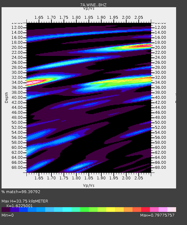
| Estimated Moho Depth: |
33.75 km |
| Estimated Crust Vp/Vs: |
1.62 |
| Assumed Crust Vp: |
6.159 km/s |
| Estimated Crust Vs: |
3.796 km/s |
| Estimated Crust Poisson's Ratio: |
0.19 |
|
| Radial Match: |
99.39792 % |
| Radial Bump: |
236 |
| Transverse Match: |
94.570694 % |
| Transverse Bump: |
400 |
| SOD ConfigId: |
7422571 |
| Insert Time: |
2019-04-20 18:57:52.857 +0000 |
| GWidth: |
2.5 |
| Max Bumps: |
400 |
| Tol: |
0.001 |
|

Signal To Noise
| Channel | StoN | STA | LTA |
| 7A:WINE: :BHZ:20150916T23:05:09.315024Z | 17.172817 | 3.401683E-6 | 1.980853E-7 |
| 7A:WINE: :BHN:20150916T23:05:09.315024Z | 12.128586 | 1.6399969E-6 | 1.3521748E-7 |
| 7A:WINE: :BHE:20150916T23:05:09.315024Z | 2.4872026 | 4.0297456E-7 | 1.6201918E-7 |
| Arrivals |
| Ps | 3.5 SECOND |
| PpPs | 14 SECOND |
| PsPs/PpSs | 17 SECOND |


