You are here: Home > Network List > IU - Global Seismograph Network (GSN - IRIS/USGS) Stations List
> Station MAKZ Makanchi, Kazakhstan > Earthquake Result Viewer
MAKZ Makanchi, Kazakhstan - Earthquake Result Viewer
| Earthquake location: |
Irian Jaya, Indonesia |
| Earthquake latitude/longitude: |
-2.7/138.9 |
| Earthquake time(UTC): |
1998/07/29 (210) 18:00:29 GMT |
| Earthquake Depth: |
33 km |
| Earthquake Magnitude: |
5.9 MB, 6.7 MS, 6.6 UNKNOWN, 6.2 ME |
| Earthquake Catalog/Contributor: |
WHDF/NEIC |
|
| Network: |
IU Global Seismograph Network (GSN - IRIS/USGS) |
| Station: |
MAKZ Makanchi, Kazakhstan |
| Lat/Lon: |
46.81 N/81.98 E |
| Elevation: |
600 m |
|
| Distance: |
70.1 deg |
| Az: |
322.254 deg |
| Baz: |
117.096 deg |
| Ray Param: |
0.055163383 |
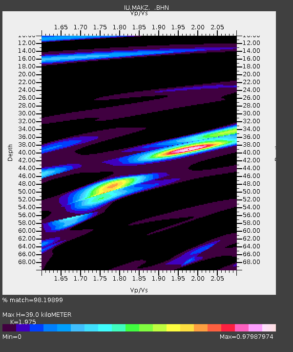
| Estimated Moho Depth: |
39.0 km |
| Estimated Crust Vp/Vs: |
1.98 |
| Assumed Crust Vp: |
6.571 km/s |
| Estimated Crust Vs: |
3.327 km/s |
| Estimated Crust Poisson's Ratio: |
0.33 |
|
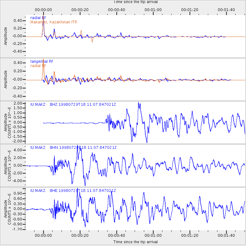
| Radial Match: |
98.19899 % |
| Radial Bump: |
298 |
| Transverse Match: |
94.98975 % |
| Transverse Bump: |
400 |
| SOD ConfigId: |
4480 |
| Insert Time: |
2010-03-04 19:34:26.385 +0000 |
| GWidth: |
2.5 |
| Max Bumps: |
400 |
| Tol: |
0.001 |
|
Signal To Noise
| Channel | StoN | STA | LTA |
| IU:MAKZ: :BHN:19980729T18:11:07.847021Z | 13.174481 | 4.0982127E-7 | 3.1107202E-8 |
| IU:MAKZ: :BHE:19980729T18:11:07.847021Z | 2.5840235 | 6.5601846E-8 | 2.538748E-8 |
| IU:MAKZ: :BHZ:19980729T18:11:07.847021Z | 6.7873273 | 1.2471159E-7 | 1.8374182E-8 |
| Arrivals |
| Ps | 6.0 SECOND |
| PpPs | 17 SECOND |
| PsPs/PpSs | 23 SECOND |


