You are here: Home > Network List > CI - Caltech Regional Seismic Network Stations List
> Station BEL Belle Mtn, Joshua Tree National Park, CA, USA > Earthquake Result Viewer
BEL Belle Mtn, Joshua Tree National Park, CA, USA - Earthquake Result Viewer
| Earthquake location: |
Near Coast Of Central Chile |
| Earthquake latitude/longitude: |
-31.6/-71.8 |
| Earthquake time(UTC): |
2015/09/16 (259) 22:54:31 GMT |
| Earthquake Depth: |
12 km |
| Earthquake Magnitude: |
8.3 MWW, 7.9 MI |
| Earthquake Catalog/Contributor: |
NEIC PDE/NEIC COMCAT |
|
| Network: |
CI Caltech Regional Seismic Network |
| Station: |
BEL Belle Mtn, Joshua Tree National Park, CA, USA |
| Lat/Lon: |
34.00 N/116.00 W |
| Elevation: |
1388 m |
|
| Distance: |
77.4 deg |
| Az: |
323.564 deg |
| Baz: |
142.4 deg |
| Ray Param: |
0.050331004 |
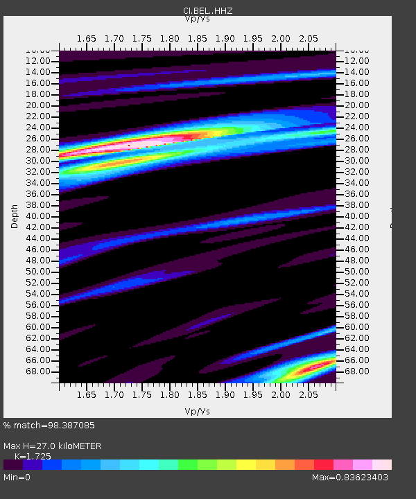
| Estimated Moho Depth: |
27.0 km |
| Estimated Crust Vp/Vs: |
1.73 |
| Assumed Crust Vp: |
6.276 km/s |
| Estimated Crust Vs: |
3.638 km/s |
| Estimated Crust Poisson's Ratio: |
0.25 |
|
| Radial Match: |
98.387085 % |
| Radial Bump: |
330 |
| Transverse Match: |
91.984215 % |
| Transverse Bump: |
400 |
| SOD ConfigId: |
7422571 |
| Insert Time: |
2019-04-20 18:58:47.444 +0000 |
| GWidth: |
2.5 |
| Max Bumps: |
400 |
| Tol: |
0.001 |
|
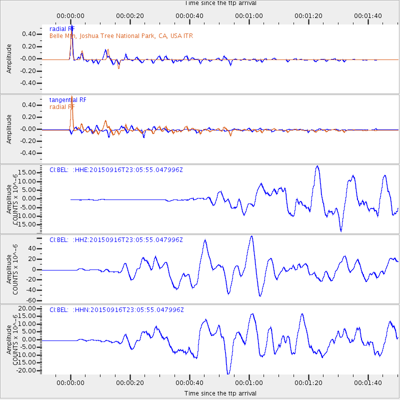
Signal To Noise
| Channel | StoN | STA | LTA |
| CI:BEL: :HHZ:20150916T23:05:55.047996Z | 11.104288 | 1.4595289E-6 | 1.3143833E-7 |
| CI:BEL: :HHN:20150916T23:05:55.047996Z | 4.919591 | 4.0539143E-7 | 8.240348E-8 |
| CI:BEL: :HHE:20150916T23:05:55.047996Z | 3.8437996 | 3.915705E-7 | 1.01870675E-7 |
| Arrivals |
| Ps | 3.2 SECOND |
| PpPs | 11 SECOND |
| PsPs/PpSs | 15 SECOND |


