You are here: Home > Network List > IU - Global Seismograph Network (GSN - IRIS/USGS) Stations List
> Station MAKZ Makanchi, Kazakhstan > Earthquake Result Viewer
MAKZ Makanchi, Kazakhstan - Earthquake Result Viewer

| Earthquake location: |
South Of Mariana Islands |
| Earthquake latitude/longitude: |
11.8/143.2 |
| Earthquake time(UTC): |
1998/09/22 (265) 01:16:55 GMT |
| Earthquake Depth: |
9.0 km |
| Earthquake Magnitude: |
5.8 MB, 5.8 MS, 6.1 UNKNOWN, 6.0 MW |
| Earthquake Catalog/Contributor: |
WHDF/NEIC |
|
| Network: |
IU Global Seismograph Network (GSN - IRIS/USGS) |
| Station: |
MAKZ Makanchi, Kazakhstan |
| Lat/Lon: |
46.81 N/81.98 E |
| Elevation: |
600 m |
|
| Distance: |
61.8 deg |
| Az: |
316.947 deg |
| Baz: |
103.329 deg |
| Ray Param: |
0.060629655 |
| Estimated Moho Depth: |
38.5 km |
| Estimated Crust Vp/Vs: |
1.95 |
| Assumed Crust Vp: |
6.571 km/s |
| Estimated Crust Vs: |
3.378 km/s |
| Estimated Crust Poisson's Ratio: |
0.32 |
|
| Radial Match: |
96.13808 % |
| Radial Bump: |
312 |
| Transverse Match: |
87.08631 % |
| Transverse Bump: |
400 |
| SOD ConfigId: |
4480 |
| Insert Time: |
2010-03-04 19:34:43.846 +0000 |
| GWidth: |
2.5 |
| Max Bumps: |
400 |
| Tol: |
0.001 |
|
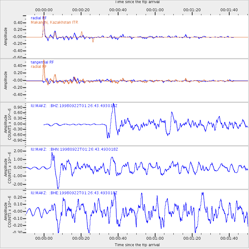
Signal To Noise
| Channel | StoN | STA | LTA |
| IU:MAKZ: :BHN:19980922T01:26:43.493018Z | 11.023252 | 5.964508E-7 | 5.4108426E-8 |
| IU:MAKZ: :BHE:19980922T01:26:43.493018Z | 1.2018679 | 4.0033832E-8 | 3.3309675E-8 |
| IU:MAKZ: :BHZ:19980922T01:26:43.493018Z | 8.3981495 | 2.4305373E-7 | 2.8941344E-8 |
| Arrivals |
| Ps | 5.8 SECOND |
| PpPs | 17 SECOND |
| PsPs/PpSs | 22 SECOND |


