You are here: Home > Network List > CI - Caltech Regional Seismic Network Stations List
> Station FMP Fort MacArthur Park, Pt. Fermin San Pedro, CA, USA > Earthquake Result Viewer
FMP Fort MacArthur Park, Pt. Fermin San Pedro, CA, USA - Earthquake Result Viewer
| Earthquake location: |
Near Coast Of Central Chile |
| Earthquake latitude/longitude: |
-31.6/-71.8 |
| Earthquake time(UTC): |
2015/09/16 (259) 22:54:31 GMT |
| Earthquake Depth: |
12 km |
| Earthquake Magnitude: |
8.3 MWW, 7.9 MI |
| Earthquake Catalog/Contributor: |
NEIC PDE/NEIC COMCAT |
|
| Network: |
CI Caltech Regional Seismic Network |
| Station: |
FMP Fort MacArthur Park, Pt. Fermin San Pedro, CA, USA |
| Lat/Lon: |
33.71 N/118.29 W |
| Elevation: |
89 m |
|
| Distance: |
78.4 deg |
| Az: |
321.851 deg |
| Baz: |
140.768 deg |
| Ray Param: |
0.04967576 |
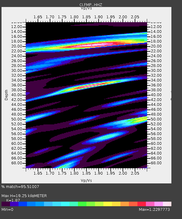
| Estimated Moho Depth: |
19.25 km |
| Estimated Crust Vp/Vs: |
1.87 |
| Assumed Crust Vp: |
6.048 km/s |
| Estimated Crust Vs: |
3.234 km/s |
| Estimated Crust Poisson's Ratio: |
0.30 |
|
| Radial Match: |
95.51007 % |
| Radial Bump: |
400 |
| Transverse Match: |
92.52245 % |
| Transverse Bump: |
400 |
| SOD ConfigId: |
7422571 |
| Insert Time: |
2019-04-20 18:58:58.476 +0000 |
| GWidth: |
2.5 |
| Max Bumps: |
400 |
| Tol: |
0.001 |
|
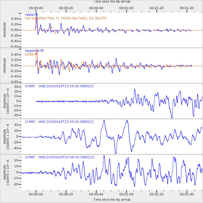
Signal To Noise
| Channel | StoN | STA | LTA |
| CI:FMP: :HHZ:20150916T23:06:00.388022Z | 6.4266176 | 1.76337E-6 | 2.743854E-7 |
| CI:FMP: :HHN:20150916T23:06:00.388022Z | 2.2015853 | 9.711289E-7 | 4.4110436E-7 |
| CI:FMP: :HHE:20150916T23:06:00.388022Z | 1.059124 | 5.559366E-7 | 5.2490225E-7 |
| Arrivals |
| Ps | 2.8 SECOND |
| PpPs | 8.9 SECOND |
| PsPs/PpSs | 12 SECOND |


