You are here: Home > Network List > IU - Global Seismograph Network (GSN - IRIS/USGS) Stations List
> Station MAKZ Makanchi, Kazakhstan > Earthquake Result Viewer
MAKZ Makanchi, Kazakhstan - Earthquake Result Viewer

| Earthquake location: |
Ceram Sea |
| Earthquake latitude/longitude: |
-2.1/124.9 |
| Earthquake time(UTC): |
1998/11/29 (333) 14:10:31 GMT |
| Earthquake Depth: |
33 km |
| Earthquake Magnitude: |
6.5 MB, 7.7 MS, 8.1 UNKNOWN, 7.8 MW |
| Earthquake Catalog/Contributor: |
WHDF/NEIC |
|
| Network: |
IU Global Seismograph Network (GSN - IRIS/USGS) |
| Station: |
MAKZ Makanchi, Kazakhstan |
| Lat/Lon: |
46.81 N/81.98 E |
| Elevation: |
600 m |
|
| Distance: |
61.5 deg |
| Az: |
327.858 deg |
| Baz: |
129.281 deg |
| Ray Param: |
0.060758963 |
| Estimated Moho Depth: |
37.0 km |
| Estimated Crust Vp/Vs: |
2.01 |
| Assumed Crust Vp: |
6.571 km/s |
| Estimated Crust Vs: |
3.265 km/s |
| Estimated Crust Poisson's Ratio: |
0.34 |
|
| Radial Match: |
97.84302 % |
| Radial Bump: |
183 |
| Transverse Match: |
92.38968 % |
| Transverse Bump: |
400 |
| SOD ConfigId: |
4480 |
| Insert Time: |
2010-03-04 19:35:07.332 +0000 |
| GWidth: |
2.5 |
| Max Bumps: |
400 |
| Tol: |
0.001 |
|
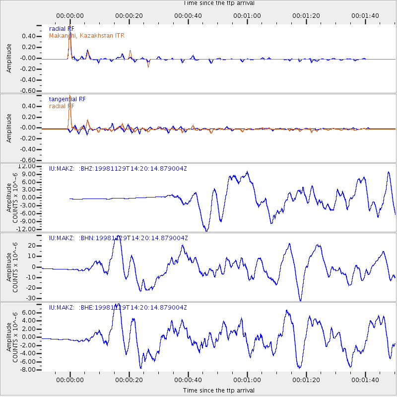
Signal To Noise
| Channel | StoN | STA | LTA |
| IU:MAKZ: :BHN:19981129T14:20:14.879004Z | 4.9018707 | 1.7904435E-6 | 3.6525716E-7 |
| IU:MAKZ: :BHE:19981129T14:20:14.879004Z | 5.1865635 | 5.74329E-7 | 1.1073403E-7 |
| IU:MAKZ: :BHZ:19981129T14:20:14.879004Z | 5.343489 | 9.008515E-7 | 1.6858863E-7 |
| Arrivals |
| Ps | 5.9 SECOND |
| PpPs | 16 SECOND |
| PsPs/PpSs | 22 SECOND |


