You are here: Home > Network List > N4 - Central and EAstern US Network Stations List
> Station M44A Midewin, Midewin Nat. Tallgrass Prarie, IL, USA > Earthquake Result Viewer
M44A Midewin, Midewin Nat. Tallgrass Prarie, IL, USA - Earthquake Result Viewer
| Earthquake location: |
Near Coast Of Central Chile |
| Earthquake latitude/longitude: |
-31.6/-71.8 |
| Earthquake time(UTC): |
2015/09/16 (259) 22:54:31 GMT |
| Earthquake Depth: |
12 km |
| Earthquake Magnitude: |
8.3 MWW, 7.9 MI |
| Earthquake Catalog/Contributor: |
NEIC PDE/NEIC COMCAT |
|
| Network: |
N4 Central and EAstern US Network |
| Station: |
M44A Midewin, Midewin Nat. Tallgrass Prarie, IL, USA |
| Lat/Lon: |
41.39 N/88.04 W |
| Elevation: |
207 m |
|
| Distance: |
74.1 deg |
| Az: |
347.325 deg |
| Baz: |
165.589 deg |
| Ray Param: |
0.052522823 |
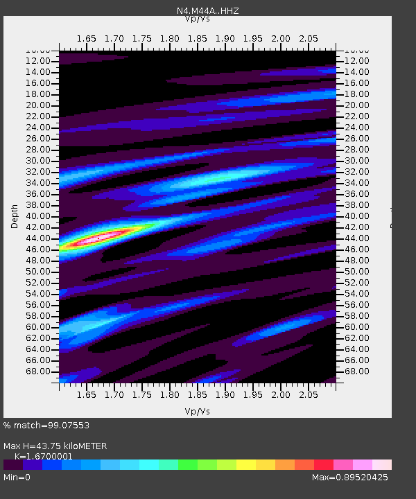
| Estimated Moho Depth: |
43.75 km |
| Estimated Crust Vp/Vs: |
1.67 |
| Assumed Crust Vp: |
6.498 km/s |
| Estimated Crust Vs: |
3.891 km/s |
| Estimated Crust Poisson's Ratio: |
0.22 |
|
| Radial Match: |
99.07553 % |
| Radial Bump: |
229 |
| Transverse Match: |
92.754166 % |
| Transverse Bump: |
400 |
| SOD ConfigId: |
7422571 |
| Insert Time: |
2019-04-20 19:02:05.580 +0000 |
| GWidth: |
2.5 |
| Max Bumps: |
400 |
| Tol: |
0.001 |
|

Signal To Noise
| Channel | StoN | STA | LTA |
| N4:M44A: :HHZ:20150916T23:05:36.26998Z | 16.200083 | 3.0902795E-6 | 1.9075704E-7 |
| N4:M44A: :HHN:20150916T23:05:36.26998Z | 4.710274 | 1.1779575E-6 | 2.500826E-7 |
| N4:M44A: :HHE:20150916T23:05:36.26998Z | 1.63574 | 4.3153872E-7 | 2.6381866E-7 |
| Arrivals |
| Ps | 4.7 SECOND |
| PpPs | 17 SECOND |
| PsPs/PpSs | 22 SECOND |


